You are here: Home > Network List > TA - USArray Transportable Network (new EarthScope stations) Stations List
> Station C40A Isle Royale National Park, MI, USA > Earthquake Result Viewer
C40A Isle Royale National Park, MI, USA - Earthquake Result Viewer
| Earthquake location: |
Kuril Islands |
| Earthquake latitude/longitude: |
45.5/151.3 |
| Earthquake time(UTC): |
2012/07/08 (190) 11:33:02 GMT |
| Earthquake Depth: |
20 km |
| Earthquake Magnitude: |
5.7 MB, 5.6 MS, 6.0 MW, 5.8 MW |
| Earthquake Catalog/Contributor: |
WHDF/NEIC |
|
| Network: |
TA USArray Transportable Network (new EarthScope stations) |
| Station: |
C40A Isle Royale National Park, MI, USA |
| Lat/Lon: |
47.92 N/89.15 W |
| Elevation: |
216 m |
|
| Distance: |
73.0 deg |
| Az: |
37.728 deg |
| Baz: |
320.225 deg |
| Ray Param: |
0.05327951 |
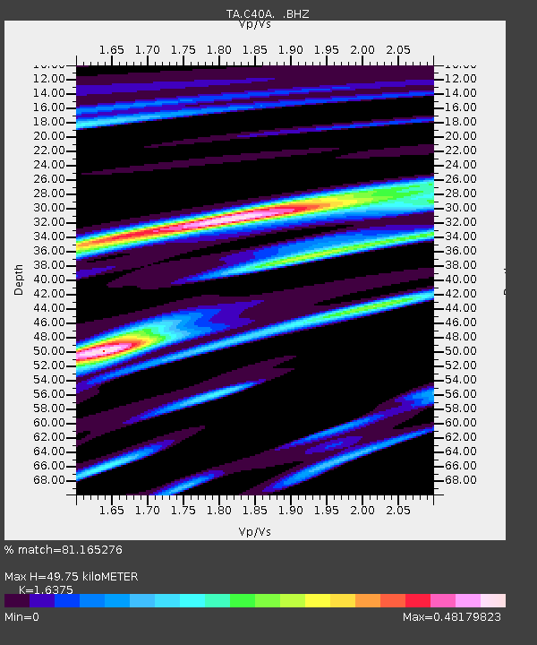
| Estimated Moho Depth: |
49.75 km |
| Estimated Crust Vp/Vs: |
1.64 |
| Assumed Crust Vp: |
6.467 km/s |
| Estimated Crust Vs: |
3.949 km/s |
| Estimated Crust Poisson's Ratio: |
0.20 |
|
| Radial Match: |
81.165276 % |
| Radial Bump: |
400 |
| Transverse Match: |
65.53194 % |
| Transverse Bump: |
400 |
| SOD ConfigId: |
466652 |
| Insert Time: |
2013-02-21 01:17:30.202 +0000 |
| GWidth: |
2.5 |
| Max Bumps: |
400 |
| Tol: |
0.001 |
|

Signal To Noise
| Channel | StoN | STA | LTA |
| TA:C40A: :BHZ:20120708T11:43:59.825029Z | 5.0131774 | 4.9052653E-7 | 9.7847426E-8 |
| TA:C40A: :BHN:20120708T11:43:59.825029Z | 3.0872056 | 2.2054265E-7 | 7.143763E-8 |
| TA:C40A: :BHE:20120708T11:43:59.825029Z | 1.7230527 | 1.4517771E-7 | 8.42561E-8 |
| Arrivals |
| Ps | 5.1 SECOND |
| PpPs | 20 SECOND |
| PsPs/PpSs | 25 SECOND |


