You are here: Home > Network List > GS - US Geological Survey Networks Stations List
> Station KAN10 Keim Farm > Earthquake Result Viewer
KAN10 Keim Farm - Earthquake Result Viewer
*The percent match for this event was below the threshold and hence no stack was calculated.
| Earthquake location: |
Mona Passage |
| Earthquake latitude/longitude: |
18.1/-68.4 |
| Earthquake time(UTC): |
2014/05/28 (148) 21:15:04 GMT |
| Earthquake Depth: |
91 km |
| Earthquake Magnitude: |
5.8 MWW, 5.3 MI, 5.9 MWR |
| Earthquake Catalog/Contributor: |
NEIC PDE/NEIC COMCAT |
|
| Network: |
GS US Geological Survey Networks |
| Station: |
KAN10 Keim Farm |
| Lat/Lon: |
37.12 N/98.10 W |
| Elevation: |
417 m |
|
| Distance: |
32.2 deg |
| Az: |
311.98 deg |
| Baz: |
117.818 deg |
| Ray Param: |
$rayparam |
*The percent match for this event was below the threshold and hence was not used in the summary stack. |
|
| Radial Match: |
53.96719 % |
| Radial Bump: |
400 |
| Transverse Match: |
38.37598 % |
| Transverse Bump: |
400 |
| SOD ConfigId: |
3390531 |
| Insert Time: |
2019-04-12 01:41:24.436 +0000 |
| GWidth: |
2.5 |
| Max Bumps: |
400 |
| Tol: |
0.001 |
|
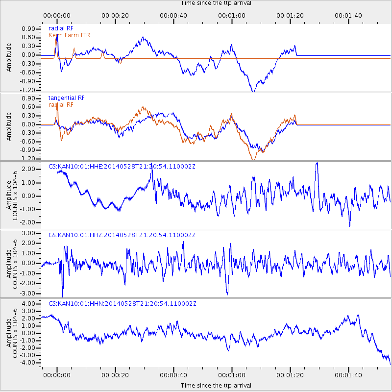
Signal To Noise
| Channel | StoN | STA | LTA |
| GS:KAN10:01:HHZ:20140528T21:20:54.110002Z | 7.2260833 | 1.0784632E-6 | 1.4924588E-7 |
| GS:KAN10:01:HHN:20140528T21:20:54.110002Z | 1.9201597 | 2.9682797E-6 | 1.5458504E-6 |
| GS:KAN10:01:HHE:20140528T21:20:54.110002Z | 1.1036335 | 9.74513E-7 | 8.830042E-7 |
| Arrivals |
| Ps | |
| PpPs | |
| PsPs/PpSs | |


