You are here: Home > Network List > TA - USArray Transportable Network (new EarthScope stations) Stations List
> Station Y50A Piedmont, AL, USA > Earthquake Result Viewer
Y50A Piedmont, AL, USA - Earthquake Result Viewer
| Earthquake location: |
Kuril Islands |
| Earthquake latitude/longitude: |
45.5/151.3 |
| Earthquake time(UTC): |
2012/07/08 (190) 11:33:02 GMT |
| Earthquake Depth: |
20 km |
| Earthquake Magnitude: |
5.7 MB, 5.6 MS, 6.0 MW, 5.8 MW |
| Earthquake Catalog/Contributor: |
WHDF/NEIC |
|
| Network: |
TA USArray Transportable Network (new EarthScope stations) |
| Station: |
Y50A Piedmont, AL, USA |
| Lat/Lon: |
33.89 N/85.73 W |
| Elevation: |
248 m |
|
| Distance: |
85.6 deg |
| Az: |
44.414 deg |
| Baz: |
323.72 deg |
| Ray Param: |
0.04460533 |
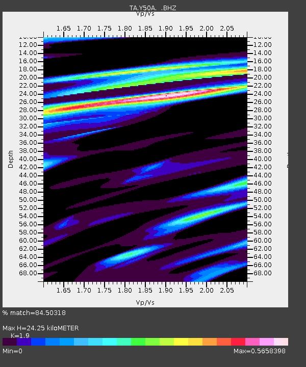
| Estimated Moho Depth: |
24.25 km |
| Estimated Crust Vp/Vs: |
1.90 |
| Assumed Crust Vp: |
6.719 km/s |
| Estimated Crust Vs: |
3.537 km/s |
| Estimated Crust Poisson's Ratio: |
0.31 |
|
| Radial Match: |
84.50318 % |
| Radial Bump: |
400 |
| Transverse Match: |
73.33642 % |
| Transverse Bump: |
400 |
| SOD ConfigId: |
466652 |
| Insert Time: |
2013-02-21 01:25:27.304 +0000 |
| GWidth: |
2.5 |
| Max Bumps: |
400 |
| Tol: |
0.001 |
|
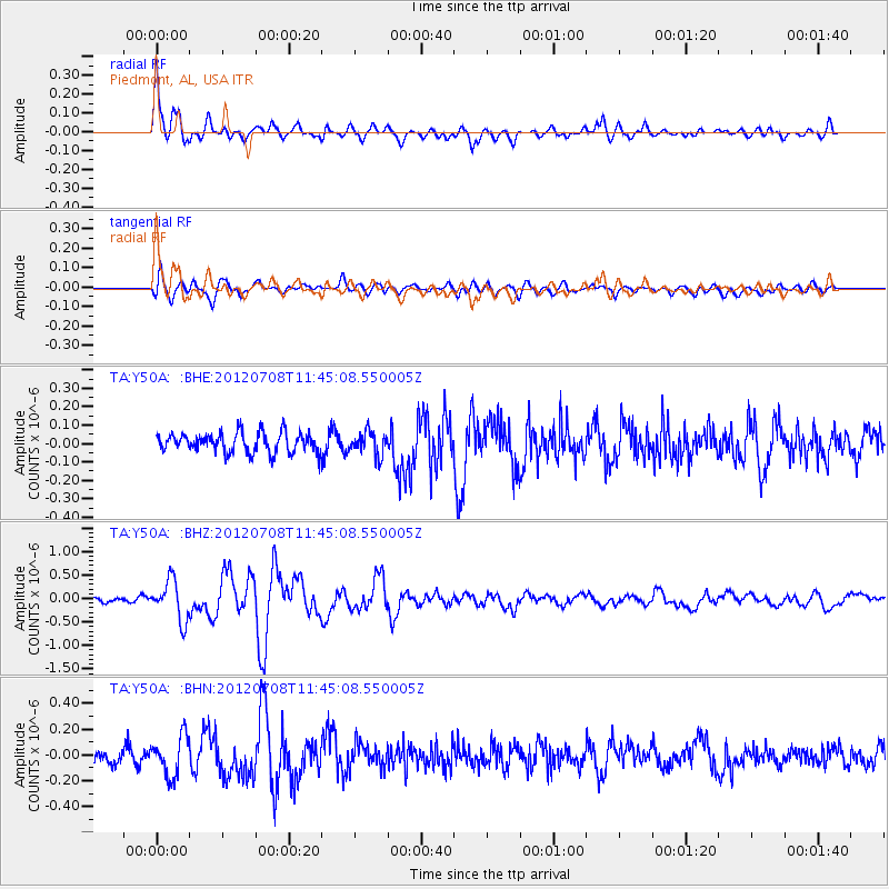
Signal To Noise
| Channel | StoN | STA | LTA |
| TA:Y50A: :BHZ:20120708T11:45:08.550005Z | 8.382637 | 4.2205565E-7 | 5.034879E-8 |
| TA:Y50A: :BHN:20120708T11:45:08.550005Z | 2.8214355 | 1.5316962E-7 | 5.428784E-8 |
| TA:Y50A: :BHE:20120708T11:45:08.550005Z | 1.1584975 | 6.178226E-8 | 5.3329643E-8 |
| Arrivals |
| Ps | 3.3 SECOND |
| PpPs | 10 SECOND |
| PsPs/PpSs | 14 SECOND |


