You are here: Home > Network List > TA - USArray Transportable Network (new EarthScope stations) Stations List
> Station Z50A Ashland, AL, USA > Earthquake Result Viewer
Z50A Ashland, AL, USA - Earthquake Result Viewer
| Earthquake location: |
Kuril Islands |
| Earthquake latitude/longitude: |
45.5/151.3 |
| Earthquake time(UTC): |
2012/07/08 (190) 11:33:02 GMT |
| Earthquake Depth: |
20 km |
| Earthquake Magnitude: |
5.7 MB, 5.6 MS, 6.0 MW, 5.8 MW |
| Earthquake Catalog/Contributor: |
WHDF/NEIC |
|
| Network: |
TA USArray Transportable Network (new EarthScope stations) |
| Station: |
Z50A Ashland, AL, USA |
| Lat/Lon: |
33.25 N/85.92 W |
| Elevation: |
370 m |
|
| Distance: |
86.1 deg |
| Az: |
44.918 deg |
| Baz: |
323.653 deg |
| Ray Param: |
0.044306975 |
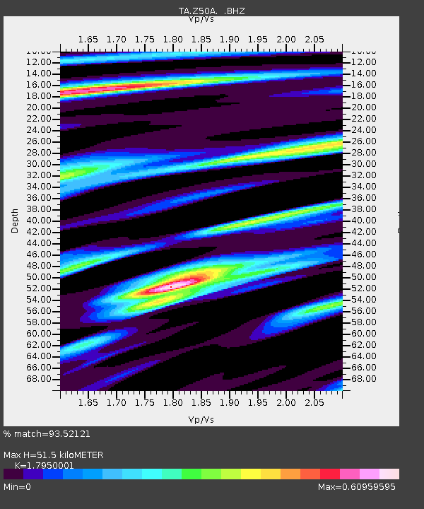
| Estimated Moho Depth: |
51.5 km |
| Estimated Crust Vp/Vs: |
1.80 |
| Assumed Crust Vp: |
6.719 km/s |
| Estimated Crust Vs: |
3.743 km/s |
| Estimated Crust Poisson's Ratio: |
0.27 |
|
| Radial Match: |
93.52121 % |
| Radial Bump: |
400 |
| Transverse Match: |
79.77109 % |
| Transverse Bump: |
400 |
| SOD ConfigId: |
466652 |
| Insert Time: |
2013-02-21 01:25:40.115 +0000 |
| GWidth: |
2.5 |
| Max Bumps: |
400 |
| Tol: |
0.001 |
|

Signal To Noise
| Channel | StoN | STA | LTA |
| TA:Z50A: :BHZ:20120708T11:45:10.625017Z | 7.316231 | 4.4008792E-7 | 6.015227E-8 |
| TA:Z50A: :BHN:20120708T11:45:10.625017Z | 4.0652905 | 1.446971E-7 | 3.5593303E-8 |
| TA:Z50A: :BHE:20120708T11:45:10.625017Z | 1.9651842 | 8.20315E-8 | 4.1742396E-8 |
| Arrivals |
| Ps | 6.3 SECOND |
| PpPs | 21 SECOND |
| PsPs/PpSs | 27 SECOND |


