You are here: Home > Network List > TA - USArray Transportable Network (new EarthScope stations) Stations List
> Station V47A Nunnelly, TN, USA > Earthquake Result Viewer
V47A Nunnelly, TN, USA - Earthquake Result Viewer
| Earthquake location: |
Kuril Islands |
| Earthquake latitude/longitude: |
45.5/151.3 |
| Earthquake time(UTC): |
2012/07/08 (190) 11:33:02 GMT |
| Earthquake Depth: |
20 km |
| Earthquake Magnitude: |
5.7 MB, 5.6 MS, 6.0 MW, 5.8 MW |
| Earthquake Catalog/Contributor: |
WHDF/NEIC |
|
| Network: |
TA USArray Transportable Network (new EarthScope stations) |
| Station: |
V47A Nunnelly, TN, USA |
| Lat/Lon: |
35.83 N/87.52 W |
| Elevation: |
240 m |
|
| Distance: |
83.2 deg |
| Az: |
44.433 deg |
| Baz: |
322.705 deg |
| Ray Param: |
0.046333827 |
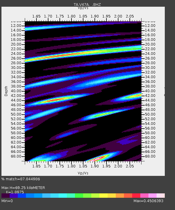
| Estimated Moho Depth: |
69.25 km |
| Estimated Crust Vp/Vs: |
1.90 |
| Assumed Crust Vp: |
6.476 km/s |
| Estimated Crust Vs: |
3.413 km/s |
| Estimated Crust Poisson's Ratio: |
0.31 |
|
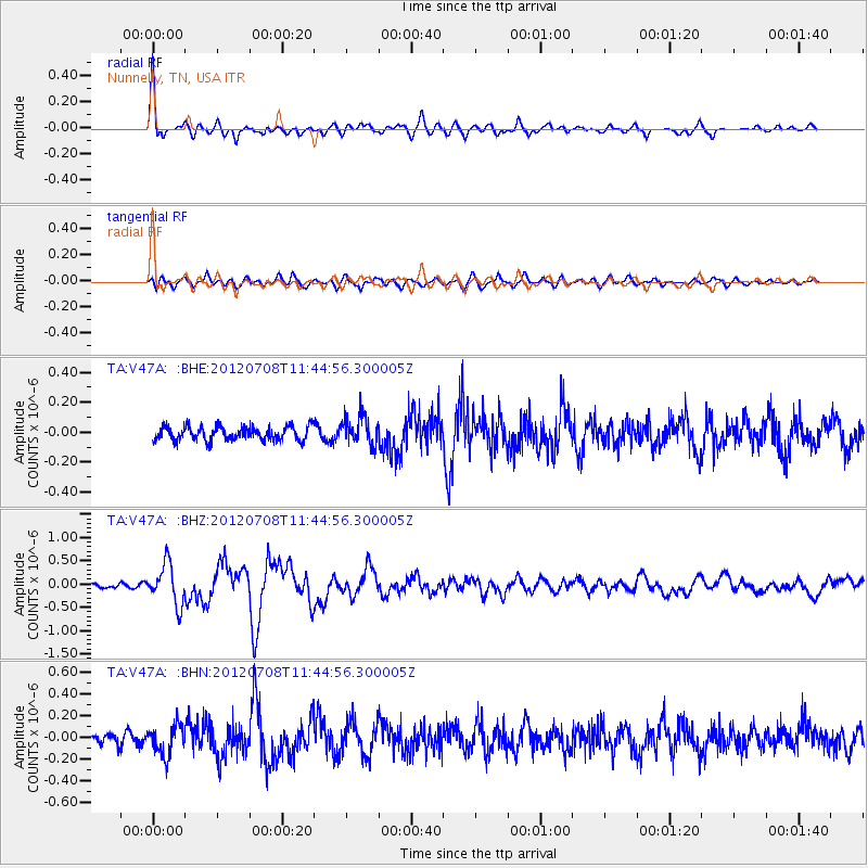
| Radial Match: |
87.844986 % |
| Radial Bump: |
400 |
| Transverse Match: |
77.18812 % |
| Transverse Bump: |
400 |
| SOD ConfigId: |
466652 |
| Insert Time: |
2013-02-21 01:25:52.854 +0000 |
| GWidth: |
2.5 |
| Max Bumps: |
400 |
| Tol: |
0.001 |
|
Signal To Noise
| Channel | StoN | STA | LTA |
| TA:V47A: :BHZ:20120708T11:44:56.300005Z | 10.613215 | 4.3094875E-7 | 4.0604917E-8 |
| TA:V47A: :BHN:20120708T11:44:56.300005Z | 2.9621146 | 1.3546973E-7 | 4.573413E-8 |
| TA:V47A: :BHE:20120708T11:44:56.300005Z | 1.996561 | 9.277412E-8 | 4.6466962E-8 |
| Arrivals |
| Ps | 9.8 SECOND |
| PpPs | 30 SECOND |
| PsPs/PpSs | 40 SECOND |


