You are here: Home > Network List > TA - USArray Transportable Network (new EarthScope stations) Stations List
> Station W48A Pulaski, TN, USA > Earthquake Result Viewer
W48A Pulaski, TN, USA - Earthquake Result Viewer
| Earthquake location: |
Kuril Islands |
| Earthquake latitude/longitude: |
45.5/151.3 |
| Earthquake time(UTC): |
2012/07/08 (190) 11:33:02 GMT |
| Earthquake Depth: |
20 km |
| Earthquake Magnitude: |
5.7 MB, 5.6 MS, 6.0 MW, 5.8 MW |
| Earthquake Catalog/Contributor: |
WHDF/NEIC |
|
| Network: |
TA USArray Transportable Network (new EarthScope stations) |
| Station: |
W48A Pulaski, TN, USA |
| Lat/Lon: |
35.14 N/86.93 W |
| Elevation: |
260 m |
|
| Distance: |
84.0 deg |
| Az: |
44.466 deg |
| Baz: |
323.048 deg |
| Ray Param: |
0.045738995 |
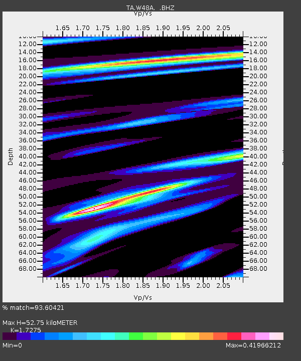
| Estimated Moho Depth: |
52.75 km |
| Estimated Crust Vp/Vs: |
1.73 |
| Assumed Crust Vp: |
6.476 km/s |
| Estimated Crust Vs: |
3.749 km/s |
| Estimated Crust Poisson's Ratio: |
0.25 |
|
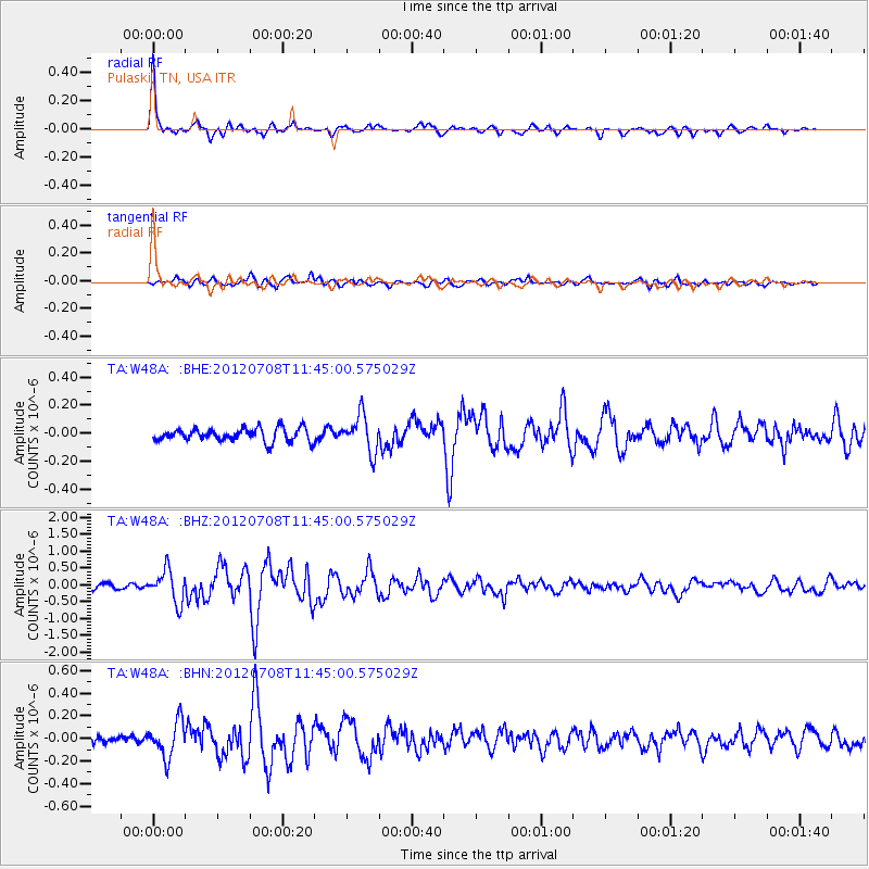
| Radial Match: |
93.60421 % |
| Radial Bump: |
307 |
| Transverse Match: |
82.03371 % |
| Transverse Bump: |
400 |
| SOD ConfigId: |
466652 |
| Insert Time: |
2013-02-21 01:26:29.005 +0000 |
| GWidth: |
2.5 |
| Max Bumps: |
400 |
| Tol: |
0.001 |
|
Signal To Noise
| Channel | StoN | STA | LTA |
| TA:W48A: :BHZ:20120708T11:45:00.575029Z | 7.22199 | 4.7820214E-7 | 6.621473E-8 |
| TA:W48A: :BHN:20120708T11:45:00.575029Z | 4.8918486 | 1.5636034E-7 | 3.1963445E-8 |
| TA:W48A: :BHE:20120708T11:45:00.575029Z | 2.8336673 | 1.311912E-7 | 4.629732E-8 |
| Arrivals |
| Ps | 6.1 SECOND |
| PpPs | 22 SECOND |
| PsPs/PpSs | 28 SECOND |


