You are here: Home > Network List > TA - USArray Transportable Network (new EarthScope stations) Stations List
> Station 151A Opelika, AL, USA > Earthquake Result Viewer
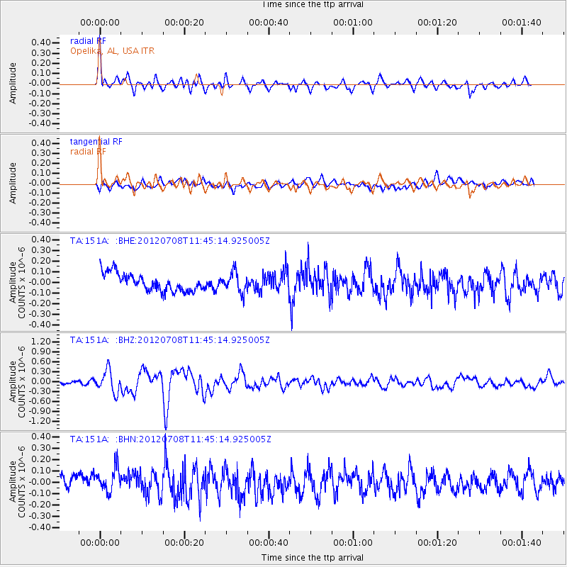
151A Opelika, AL, USA - Earthquake Result Viewer
*The percent match for this event was below the threshold and hence no stack was calculated.
| Earthquake location: |
Kuril Islands |
| Earthquake latitude/longitude: |
45.5/151.3 |
| Earthquake time(UTC): |
2012/07/08 (190) 11:33:02 GMT |
| Earthquake Depth: |
20 km |
| Earthquake Magnitude: |
5.7 MB, 5.6 MS, 6.0 MW, 5.8 MW |
| Earthquake Catalog/Contributor: |
WHDF/NEIC |
|
| Network: |
TA USArray Transportable Network (new EarthScope stations) |
| Station: |
151A Opelika, AL, USA |
| Lat/Lon: |
32.53 N/85.33 W |
| Elevation: |
211 m |
|
| Distance: |
86.9 deg |
| Az: |
44.941 deg |
| Baz: |
323.976 deg |
| Ray Param: |
$rayparam |
*The percent match for this event was below the threshold and hence was not used in the summary stack. |
|
| Radial Match: |
77.94058 % |
| Radial Bump: |
400 |
| Transverse Match: |
54.648743 % |
| Transverse Bump: |
400 |
| SOD ConfigId: |
466652 |
| Insert Time: |
2013-02-21 01:27:19.241 +0000 |
| GWidth: |
2.5 |
| Max Bumps: |
400 |
| Tol: |
0.001 |
|
Signal To Noise
| Channel | StoN | STA | LTA |
| TA:151A: :BHZ:20120708T11:45:14.925005Z | 5.5259247 | 3.431307E-7 | 6.2094706E-8 |
| TA:151A: :BHN:20120708T11:45:14.925005Z | 1.7648206 | 1.14509575E-7 | 6.488454E-8 |
| TA:151A: :BHE:20120708T11:45:14.925005Z | 1.1443169 | 9.346432E-8 | 8.167695E-8 |
| Arrivals |
| Ps | |
| PpPs | |
| PsPs/PpSs | |


