You are here: Home > Network List > TA - USArray Transportable Network (new EarthScope stations) Stations List
> Station 253A Americus, GA, USA > Earthquake Result Viewer
253A Americus, GA, USA - Earthquake Result Viewer
| Earthquake location: |
Kuril Islands |
| Earthquake latitude/longitude: |
45.5/151.3 |
| Earthquake time(UTC): |
2012/07/08 (190) 11:33:02 GMT |
| Earthquake Depth: |
20 km |
| Earthquake Magnitude: |
5.7 MB, 5.6 MS, 6.0 MW, 5.8 MW |
| Earthquake Catalog/Contributor: |
WHDF/NEIC |
|
| Network: |
TA USArray Transportable Network (new EarthScope stations) |
| Station: |
253A Americus, GA, USA |
| Lat/Lon: |
32.06 N/84.13 W |
| Elevation: |
136 m |
|
| Distance: |
87.9 deg |
| Az: |
44.389 deg |
| Baz: |
324.588 deg |
| Ray Param: |
0.042965654 |
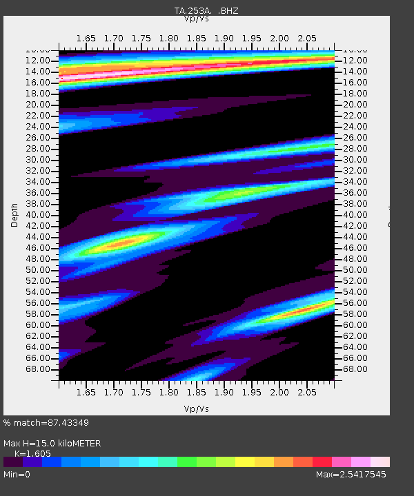
| Estimated Moho Depth: |
15.0 km |
| Estimated Crust Vp/Vs: |
1.61 |
| Assumed Crust Vp: |
6.719 km/s |
| Estimated Crust Vs: |
4.187 km/s |
| Estimated Crust Poisson's Ratio: |
0.18 |
|
| Radial Match: |
87.43349 % |
| Radial Bump: |
331 |
| Transverse Match: |
69.47773 % |
| Transverse Bump: |
338 |
| SOD ConfigId: |
466652 |
| Insert Time: |
2013-02-21 01:31:27.632 +0000 |
| GWidth: |
2.5 |
| Max Bumps: |
400 |
| Tol: |
0.001 |
|

Signal To Noise
| Channel | StoN | STA | LTA |
| TA:253A: :BHZ:20120708T11:45:19.575029Z | 3.6069493 | 4.817678E-7 | 1.3356656E-7 |
| TA:253A: :BHN:20120708T11:45:19.575029Z | 1.0542035 | 1.8123502E-7 | 1.7191655E-7 |
| TA:253A: :BHE:20120708T11:45:19.575029Z | 0.92923933 | 2.8148085E-7 | 3.0291537E-7 |
| Arrivals |
| Ps | 1.4 SECOND |
| PpPs | 5.7 SECOND |
| PsPs/PpSs | 7.0 SECOND |


