You are here: Home > Network List > TA - USArray Transportable Network (new EarthScope stations) Stations List
> Station 252A Lumpkin, GA, USA > Earthquake Result Viewer
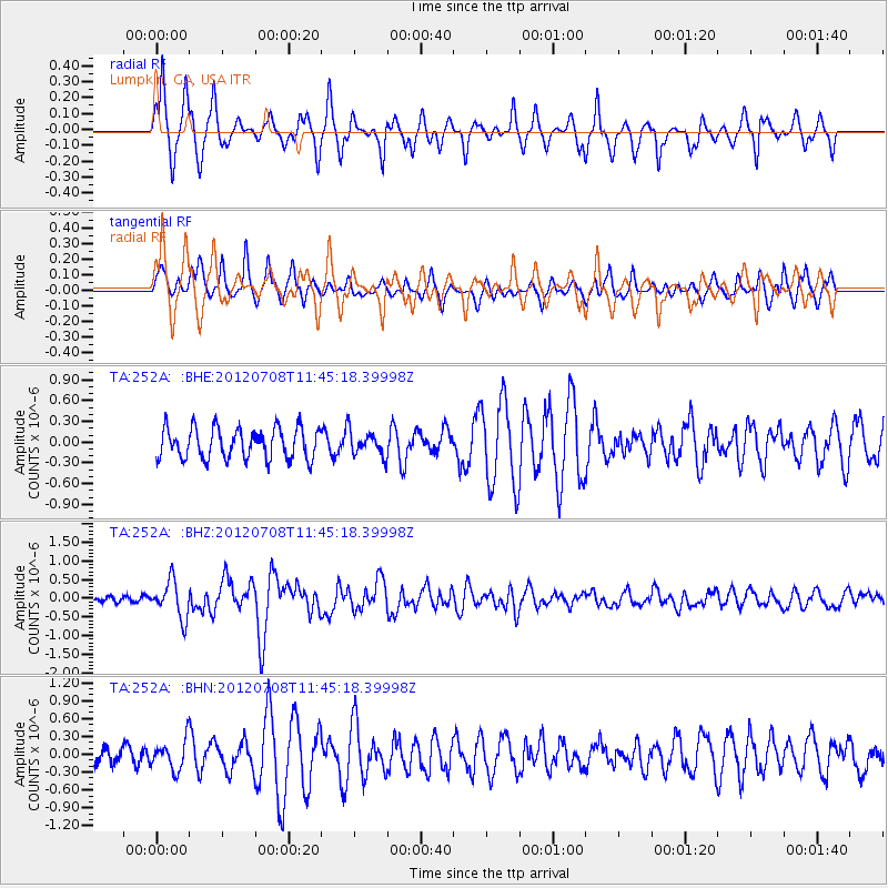
252A Lumpkin, GA, USA - Earthquake Result Viewer
*The percent match for this event was below the threshold and hence no stack was calculated.
| Earthquake location: |
Kuril Islands |
| Earthquake latitude/longitude: |
45.5/151.3 |
| Earthquake time(UTC): |
2012/07/08 (190) 11:33:02 GMT |
| Earthquake Depth: |
20 km |
| Earthquake Magnitude: |
5.7 MB, 5.6 MS, 6.0 MW, 5.8 MW |
| Earthquake Catalog/Contributor: |
WHDF/NEIC |
|
| Network: |
TA USArray Transportable Network (new EarthScope stations) |
| Station: |
252A Lumpkin, GA, USA |
| Lat/Lon: |
32.00 N/84.74 W |
| Elevation: |
142 m |
|
| Distance: |
87.7 deg |
| Az: |
44.846 deg |
| Baz: |
324.286 deg |
| Ray Param: |
$rayparam |
*The percent match for this event was below the threshold and hence was not used in the summary stack. |
|
| Radial Match: |
77.95916 % |
| Radial Bump: |
328 |
| Transverse Match: |
68.79634 % |
| Transverse Bump: |
381 |
| SOD ConfigId: |
466652 |
| Insert Time: |
2013-02-21 01:31:39.717 +0000 |
| GWidth: |
2.5 |
| Max Bumps: |
400 |
| Tol: |
0.001 |
|
Signal To Noise
| Channel | StoN | STA | LTA |
| TA:252A: :BHZ:20120708T11:45:18.39998Z | 5.1506476 | 4.9000874E-7 | 9.513536E-8 |
| TA:252A: :BHN:20120708T11:45:18.39998Z | 1.1530634 | 2.4274348E-7 | 2.105205E-7 |
| TA:252A: :BHE:20120708T11:45:18.39998Z | 0.77309936 | 1.7077589E-7 | 2.2089772E-7 |
| Arrivals |
| Ps | |
| PpPs | |
| PsPs/PpSs | |


