You are here: Home > Network List > TA - USArray Transportable Network (new EarthScope stations) Stations List
> Station U52A Thorn Hill, TN, USA > Earthquake Result Viewer
U52A Thorn Hill, TN, USA - Earthquake Result Viewer
| Earthquake location: |
Kuril Islands |
| Earthquake latitude/longitude: |
45.5/151.3 |
| Earthquake time(UTC): |
2012/07/08 (190) 11:33:02 GMT |
| Earthquake Depth: |
20 km |
| Earthquake Magnitude: |
5.7 MB, 5.6 MS, 6.0 MW, 5.8 MW |
| Earthquake Catalog/Contributor: |
WHDF/NEIC |
|
| Network: |
TA USArray Transportable Network (new EarthScope stations) |
| Station: |
U52A Thorn Hill, TN, USA |
| Lat/Lon: |
36.39 N/83.37 W |
| Elevation: |
510 m |
|
| Distance: |
84.7 deg |
| Az: |
41.371 deg |
| Baz: |
324.822 deg |
| Ray Param: |
0.045246597 |
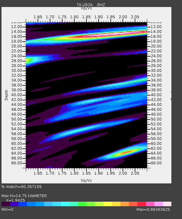
| Estimated Moho Depth: |
14.75 km |
| Estimated Crust Vp/Vs: |
1.94 |
| Assumed Crust Vp: |
6.476 km/s |
| Estimated Crust Vs: |
3.334 km/s |
| Estimated Crust Poisson's Ratio: |
0.32 |
|
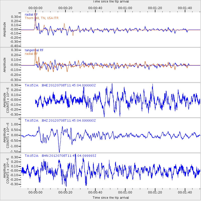
| Radial Match: |
80.357185 % |
| Radial Bump: |
400 |
| Transverse Match: |
61.40648 % |
| Transverse Bump: |
400 |
| SOD ConfigId: |
466652 |
| Insert Time: |
2013-02-21 01:39:28.518 +0000 |
| GWidth: |
2.5 |
| Max Bumps: |
400 |
| Tol: |
0.001 |
|
Signal To Noise
| Channel | StoN | STA | LTA |
| TA:U52A: :BHZ:20120708T11:45:04.099993Z | 5.25137 | 3.957249E-7 | 7.535651E-8 |
| TA:U52A: :BHN:20120708T11:45:04.099993Z | 1.5579646 | 1.08300284E-7 | 6.951396E-8 |
| TA:U52A: :BHE:20120708T11:45:04.099993Z | 1.4474043 | 9.1215234E-8 | 6.3019876E-8 |
| Arrivals |
| Ps | 2.2 SECOND |
| PpPs | 6.6 SECOND |
| PsPs/PpSs | 8.7 SECOND |


