You are here: Home > Network List > TA - USArray Transportable Network (new EarthScope stations) Stations List
> Station S49A Springfield, KY, USA > Earthquake Result Viewer
S49A Springfield, KY, USA - Earthquake Result Viewer
| Earthquake location: |
Kuril Islands |
| Earthquake latitude/longitude: |
45.5/151.3 |
| Earthquake time(UTC): |
2012/07/08 (190) 11:33:02 GMT |
| Earthquake Depth: |
20 km |
| Earthquake Magnitude: |
5.7 MB, 5.6 MS, 6.0 MW, 5.8 MW |
| Earthquake Catalog/Contributor: |
WHDF/NEIC |
|
| Network: |
TA USArray Transportable Network (new EarthScope stations) |
| Station: |
S49A Springfield, KY, USA |
| Lat/Lon: |
37.78 N/85.29 W |
| Elevation: |
230 m |
|
| Distance: |
82.7 deg |
| Az: |
41.809 deg |
| Baz: |
323.716 deg |
| Ray Param: |
0.046675205 |
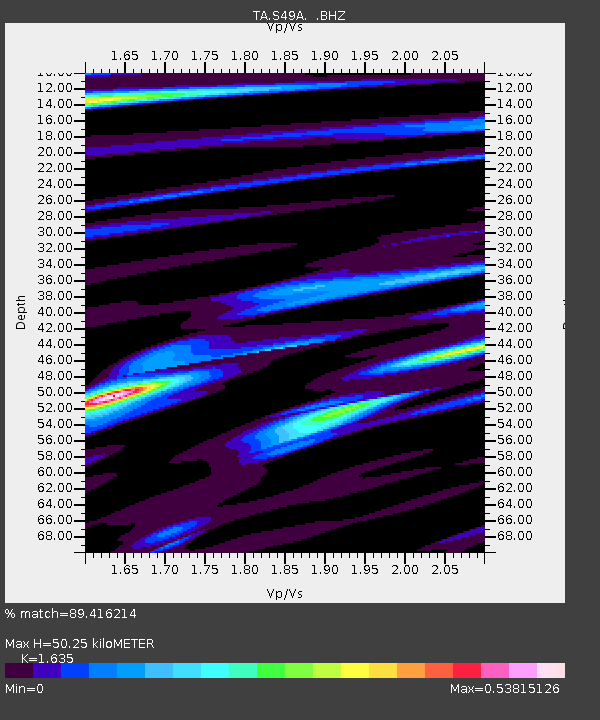
| Estimated Moho Depth: |
50.25 km |
| Estimated Crust Vp/Vs: |
1.63 |
| Assumed Crust Vp: |
6.476 km/s |
| Estimated Crust Vs: |
3.961 km/s |
| Estimated Crust Poisson's Ratio: |
0.20 |
|
| Radial Match: |
89.416214 % |
| Radial Bump: |
321 |
| Transverse Match: |
78.23629 % |
| Transverse Bump: |
400 |
| SOD ConfigId: |
466652 |
| Insert Time: |
2013-02-21 01:40:42.637 +0000 |
| GWidth: |
2.5 |
| Max Bumps: |
400 |
| Tol: |
0.001 |
|

Signal To Noise
| Channel | StoN | STA | LTA |
| TA:S49A: :BHZ:20120708T11:44:53.77498Z | 4.544823 | 5.088918E-7 | 1.11971744E-7 |
| TA:S49A: :BHN:20120708T11:44:53.77498Z | 2.907631 | 1.5793415E-7 | 5.4317127E-8 |
| TA:S49A: :BHE:20120708T11:44:53.77498Z | 2.644317 | 1.2325249E-7 | 4.6610328E-8 |
| Arrivals |
| Ps | 5.1 SECOND |
| PpPs | 20 SECOND |
| PsPs/PpSs | 25 SECOND |


