You are here: Home > Network List > TA - USArray Transportable Network (new EarthScope stations) Stations List
> Station Q48A North Vernon, IN, USA > Earthquake Result Viewer
Q48A North Vernon, IN, USA - Earthquake Result Viewer
| Earthquake location: |
Kuril Islands |
| Earthquake latitude/longitude: |
45.5/151.3 |
| Earthquake time(UTC): |
2012/07/08 (190) 11:33:02 GMT |
| Earthquake Depth: |
20 km |
| Earthquake Magnitude: |
5.7 MB, 5.6 MS, 6.0 MW, 5.8 MW |
| Earthquake Catalog/Contributor: |
WHDF/NEIC |
|
| Network: |
TA USArray Transportable Network (new EarthScope stations) |
| Station: |
Q48A North Vernon, IN, USA |
| Lat/Lon: |
38.93 N/85.73 W |
| Elevation: |
185 m |
|
| Distance: |
81.6 deg |
| Az: |
41.406 deg |
| Baz: |
323.387 deg |
| Ray Param: |
0.0474606 |
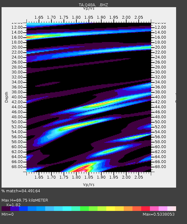
| Estimated Moho Depth: |
69.75 km |
| Estimated Crust Vp/Vs: |
1.82 |
| Assumed Crust Vp: |
6.498 km/s |
| Estimated Crust Vs: |
3.57 km/s |
| Estimated Crust Poisson's Ratio: |
0.28 |
|
| Radial Match: |
84.49164 % |
| Radial Bump: |
238 |
| Transverse Match: |
78.69753 % |
| Transverse Bump: |
400 |
| SOD ConfigId: |
466652 |
| Insert Time: |
2013-02-21 01:42:20.851 +0000 |
| GWidth: |
2.5 |
| Max Bumps: |
400 |
| Tol: |
0.001 |
|
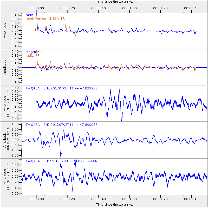
Signal To Noise
| Channel | StoN | STA | LTA |
| TA:Q48A: :BHZ:20120708T11:44:47.89998Z | 5.833314 | 4.421434E-7 | 7.5796265E-8 |
| TA:Q48A: :BHN:20120708T11:44:47.89998Z | 2.4142447 | 1.4733187E-7 | 6.102608E-8 |
| TA:Q48A: :BHE:20120708T11:44:47.89998Z | 1.8520166 | 1.166487E-7 | 6.29847E-8 |
| Arrivals |
| Ps | 9.0 SECOND |
| PpPs | 29 SECOND |
| PsPs/PpSs | 39 SECOND |


