You are here: Home > Network List > CN - Canadian National Seismograph Network Stations List
> Station INK INUVIK, NT > Earthquake Result Viewer
INK INUVIK, NT - Earthquake Result Viewer
*The percent match for this event was below the threshold and hence no stack was calculated.
| Earthquake location: |
Eastern Mediterranean Sea |
| Earthquake latitude/longitude: |
35.6/28.9 |
| Earthquake time(UTC): |
2012/07/09 (191) 13:55:00 GMT |
| Earthquake Depth: |
56 km |
| Earthquake Magnitude: |
5.6 MB, 5.6 MW, 5.6 MW |
| Earthquake Catalog/Contributor: |
WHDF/NEIC |
|
| Network: |
CN Canadian National Seismograph Network |
| Station: |
INK INUVIK, NT |
| Lat/Lon: |
68.31 N/133.53 W |
| Elevation: |
44 m |
|
| Distance: |
75.6 deg |
| Az: |
353.35 deg |
| Baz: |
14.703 deg |
| Ray Param: |
$rayparam |
*The percent match for this event was below the threshold and hence was not used in the summary stack. |
|
| Radial Match: |
65.22089 % |
| Radial Bump: |
400 |
| Transverse Match: |
61.670788 % |
| Transverse Bump: |
400 |
| SOD ConfigId: |
466652 |
| Insert Time: |
2013-02-21 01:53:44.890 +0000 |
| GWidth: |
2.5 |
| Max Bumps: |
400 |
| Tol: |
0.001 |
|
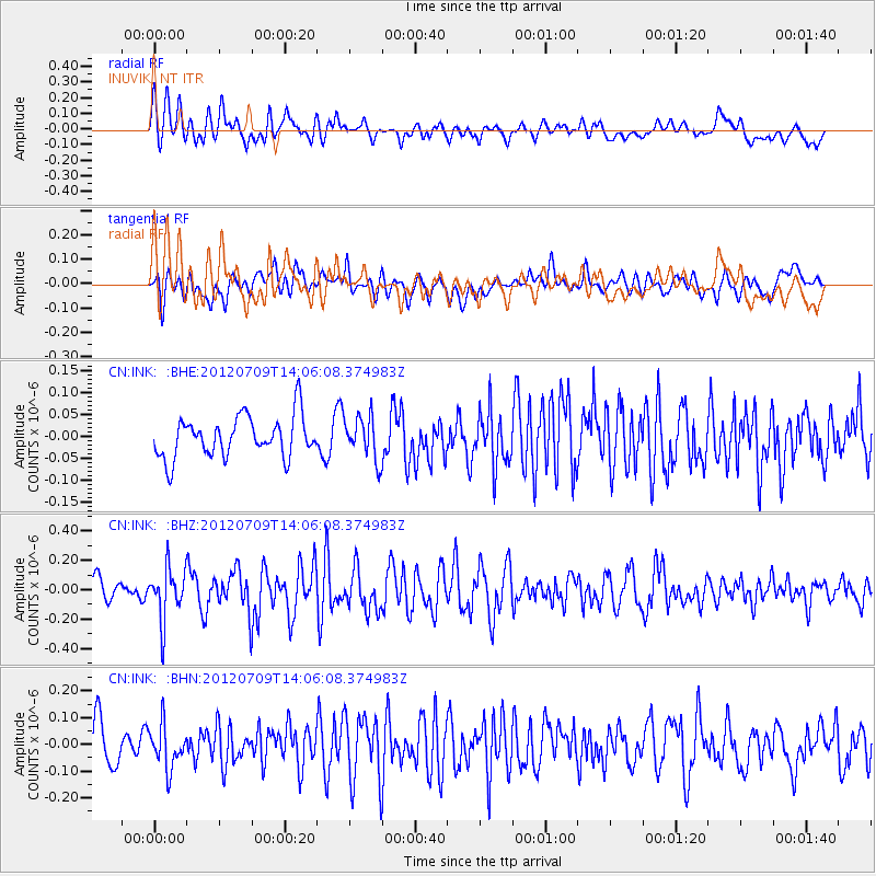
Signal To Noise
| Channel | StoN | STA | LTA |
| CN:INK: :BHZ:20120709T14:06:08.374983Z | 2.2858431 | 1.7601641E-7 | 7.700284E-8 |
| CN:INK: :BHN:20120709T14:06:08.374983Z | 1.1912738 | 7.92215E-8 | 6.650151E-8 |
| CN:INK: :BHE:20120709T14:06:08.374983Z | 1.0518389 | 4.9001525E-8 | 4.658653E-8 |
| Arrivals |
| Ps | |
| PpPs | |
| PsPs/PpSs | |


