You are here: Home > Network List > TA - USArray Transportable Network (new EarthScope stations) Stations List
> Station K40A Colesburg, IA, USA > Earthquake Result Viewer
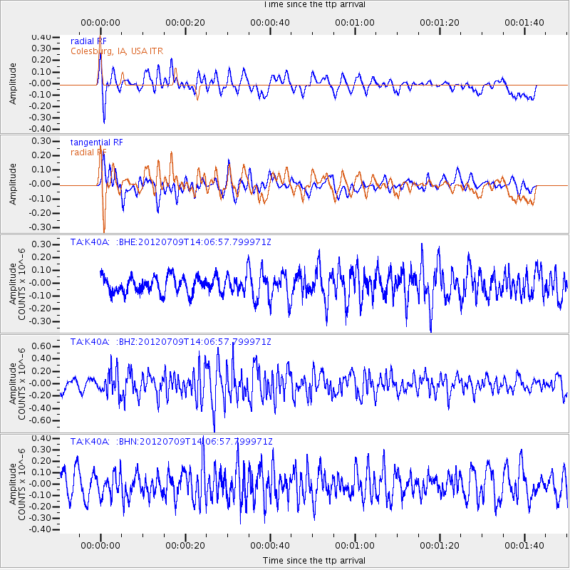
K40A Colesburg, IA, USA - Earthquake Result Viewer
*The percent match for this event was below the threshold and hence no stack was calculated.
| Earthquake location: |
Eastern Mediterranean Sea |
| Earthquake latitude/longitude: |
35.6/28.9 |
| Earthquake time(UTC): |
2012/07/09 (191) 13:55:00 GMT |
| Earthquake Depth: |
56 km |
| Earthquake Magnitude: |
5.6 MB, 5.6 MW, 5.6 MW |
| Earthquake Catalog/Contributor: |
WHDF/NEIC |
|
| Network: |
TA USArray Transportable Network (new EarthScope stations) |
| Station: |
K40A Colesburg, IA, USA |
| Lat/Lon: |
42.70 N/91.14 W |
| Elevation: |
274 m |
|
| Distance: |
84.8 deg |
| Az: |
320.157 deg |
| Baz: |
45.092 deg |
| Ray Param: |
$rayparam |
*The percent match for this event was below the threshold and hence was not used in the summary stack. |
|
| Radial Match: |
69.69777 % |
| Radial Bump: |
400 |
| Transverse Match: |
48.29836 % |
| Transverse Bump: |
400 |
| SOD ConfigId: |
466652 |
| Insert Time: |
2013-02-21 02:58:20.099 +0000 |
| GWidth: |
2.5 |
| Max Bumps: |
400 |
| Tol: |
0.001 |
|
Signal To Noise
| Channel | StoN | STA | LTA |
| TA:K40A: :BHZ:20120709T14:06:57.799971Z | 2.5901635 | 1.8570667E-7 | 7.169689E-8 |
| TA:K40A: :BHN:20120709T14:06:57.799971Z | 1.1764241 | 9.503414E-8 | 8.07822E-8 |
| TA:K40A: :BHE:20120709T14:06:57.799971Z | 1.0905588 | 6.9849875E-8 | 6.404962E-8 |
| Arrivals |
| Ps | |
| PpPs | |
| PsPs/PpSs | |


