You are here: Home > Network List > TA - USArray Transportable Network (new EarthScope stations) Stations List
> Station R42A Luebbering, MO, USA > Earthquake Result Viewer
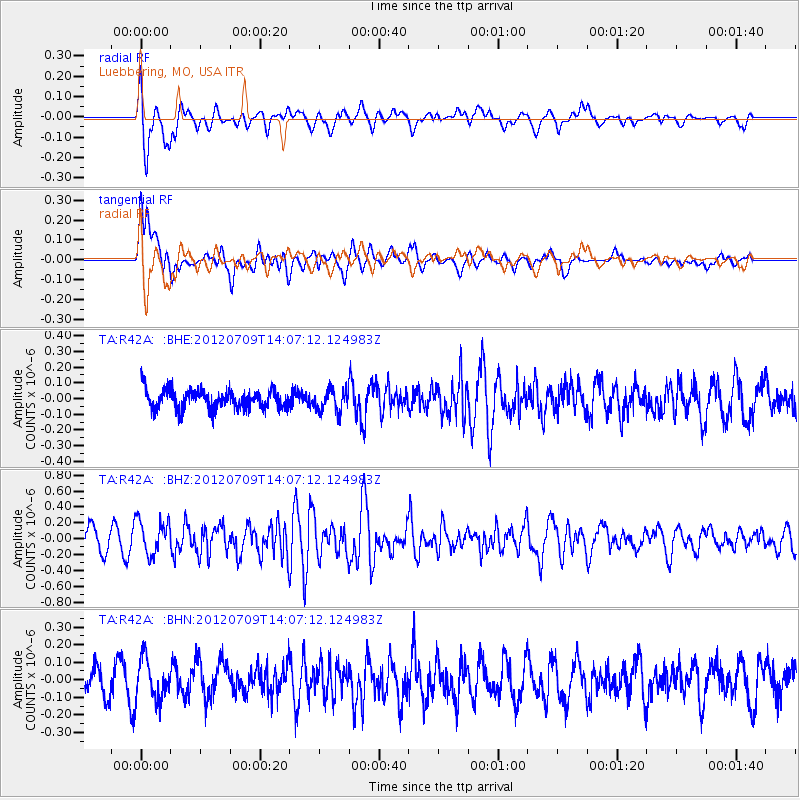
R42A Luebbering, MO, USA - Earthquake Result Viewer
*The percent match for this event was below the threshold and hence no stack was calculated.
| Earthquake location: |
Eastern Mediterranean Sea |
| Earthquake latitude/longitude: |
35.6/28.9 |
| Earthquake time(UTC): |
2012/07/09 (191) 13:55:00 GMT |
| Earthquake Depth: |
56 km |
| Earthquake Magnitude: |
5.6 MB, 5.6 MW, 5.6 MW |
| Earthquake Catalog/Contributor: |
WHDF/NEIC |
|
| Network: |
TA USArray Transportable Network (new EarthScope stations) |
| Station: |
R42A Luebbering, MO, USA |
| Lat/Lon: |
38.28 N/90.79 W |
| Elevation: |
218 m |
|
| Distance: |
87.7 deg |
| Az: |
316.838 deg |
| Baz: |
45.098 deg |
| Ray Param: |
$rayparam |
*The percent match for this event was below the threshold and hence was not used in the summary stack. |
|
| Radial Match: |
79.18326 % |
| Radial Bump: |
400 |
| Transverse Match: |
54.685143 % |
| Transverse Bump: |
400 |
| SOD ConfigId: |
466652 |
| Insert Time: |
2013-02-21 02:59:37.160 +0000 |
| GWidth: |
2.5 |
| Max Bumps: |
400 |
| Tol: |
0.001 |
|
Signal To Noise
| Channel | StoN | STA | LTA |
| TA:R42A: :BHZ:20120709T14:07:12.124983Z | 2.0226843 | 2.1891384E-7 | 1.08229365E-7 |
| TA:R42A: :BHN:20120709T14:07:12.124983Z | 1.8389038 | 1.1479022E-7 | 6.2423176E-8 |
| TA:R42A: :BHE:20120709T14:07:12.124983Z | 1.1278439 | 6.760854E-8 | 5.9944945E-8 |
| Arrivals |
| Ps | |
| PpPs | |
| PsPs/PpSs | |


