You are here: Home > Network List > G - GEOSCOPE Stations List
> Station SSB Saint Sauveur Badole, France > Earthquake Result Viewer
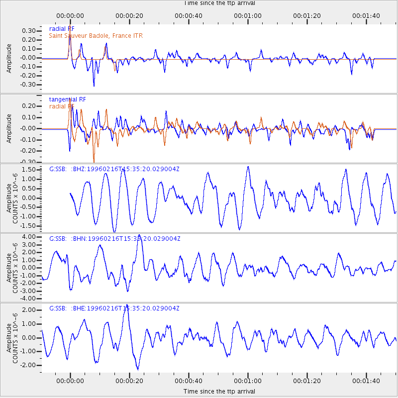
SSB Saint Sauveur Badole, France - Earthquake Result Viewer
*The percent match for this event was below the threshold and hence no stack was calculated.
| Earthquake location: |
Off East Coast Of Honshu, Japan |
| Earthquake latitude/longitude: |
37.3/142.5 |
| Earthquake time(UTC): |
1996/02/16 (047) 15:22:57 GMT |
| Earthquake Depth: |
33 km |
| Earthquake Magnitude: |
6.2 MB, 6.2 MS, 6.7 UNKNOWN, 6.6 MW |
| Earthquake Catalog/Contributor: |
WHDF/NEIC |
|
| Network: |
G GEOSCOPE |
| Station: |
SSB Saint Sauveur Badole, France |
| Lat/Lon: |
45.28 N/4.54 E |
| Elevation: |
700 m |
|
| Distance: |
89.4 deg |
| Az: |
331.766 deg |
| Baz: |
32.277 deg |
| Ray Param: |
$rayparam |
*The percent match for this event was below the threshold and hence was not used in the summary stack. |
|
| Radial Match: |
59.360794 % |
| Radial Bump: |
269 |
| Transverse Match: |
66.57238 % |
| Transverse Bump: |
400 |
| SOD ConfigId: |
4480 |
| Insert Time: |
2010-02-27 00:17:26.819 +0000 |
| GWidth: |
2.5 |
| Max Bumps: |
400 |
| Tol: |
0.001 |
|
Signal To Noise
| Channel | StoN | STA | LTA |
| G:SSB: :BHN:19960216T15:35:20.029004Z | 2.080799 | 1.4900488E-6 | 7.160945E-7 |
| G:SSB: :BHE:19960216T15:35:20.029004Z | 1.2649825 | 7.7376313E-7 | 6.1167896E-7 |
| G:SSB: :BHZ:19960216T15:35:20.029004Z | 0.5751452 | 5.367498E-7 | 9.3324223E-7 |
| Arrivals |
| Ps | |
| PpPs | |
| PsPs/PpSs | |


