You are here: Home > Network List > TA - USArray Transportable Network (new EarthScope stations) Stations List
> Station O47A Sheridan, IN, USA > Earthquake Result Viewer
O47A Sheridan, IN, USA - Earthquake Result Viewer
*The percent match for this event was below the threshold and hence no stack was calculated.
| Earthquake location: |
Eastern Mediterranean Sea |
| Earthquake latitude/longitude: |
35.6/28.9 |
| Earthquake time(UTC): |
2012/07/09 (191) 13:55:00 GMT |
| Earthquake Depth: |
56 km |
| Earthquake Magnitude: |
5.6 MB, 5.6 MW, 5.6 MW |
| Earthquake Catalog/Contributor: |
WHDF/NEIC |
|
| Network: |
TA USArray Transportable Network (new EarthScope stations) |
| Station: |
O47A Sheridan, IN, USA |
| Lat/Lon: |
40.24 N/86.17 W |
| Elevation: |
278 m |
|
| Distance: |
83.8 deg |
| Az: |
315.783 deg |
| Baz: |
47.933 deg |
| Ray Param: |
$rayparam |
*The percent match for this event was below the threshold and hence was not used in the summary stack. |
|
| Radial Match: |
57.347134 % |
| Radial Bump: |
400 |
| Transverse Match: |
49.438957 % |
| Transverse Bump: |
400 |
| SOD ConfigId: |
466652 |
| Insert Time: |
2013-02-21 03:02:02.920 +0000 |
| GWidth: |
2.5 |
| Max Bumps: |
400 |
| Tol: |
0.001 |
|
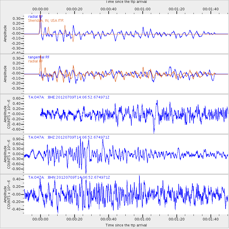
Signal To Noise
| Channel | StoN | STA | LTA |
| TA:O47A: :BHZ:20120709T14:06:52.674971Z | 2.2274373 | 2.4622952E-7 | 1.10543866E-7 |
| TA:O47A: :BHN:20120709T14:06:52.674971Z | 1.3266947 | 1.7886492E-7 | 1.3481996E-7 |
| TA:O47A: :BHE:20120709T14:06:52.674971Z | 1.0571879 | 1.1130055E-7 | 1.0527981E-7 |
| Arrivals |
| Ps | |
| PpPs | |
| PsPs/PpSs | |


