You are here: Home > Network List > CI - Caltech Regional Seismic Network Stations List
> Station FMP Fort MacArthur Park, Pt. Fermin San Pedro, CA, USA > Earthquake Result Viewer
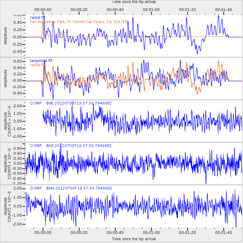
FMP Fort MacArthur Park, Pt. Fermin San Pedro, CA, USA - Earthquake Result Viewer
*The percent match for this event was below the threshold and hence no stack was calculated.
| Earthquake location: |
Ryukyu Islands, Japan |
| Earthquake latitude/longitude: |
29.4/130.1 |
| Earthquake time(UTC): |
2012/07/09 (191) 19:25:07 GMT |
| Earthquake Depth: |
39 km |
| Earthquake Magnitude: |
5.6 MW, 5.1 MS, 5.1 MB, 5.5 MW |
| Earthquake Catalog/Contributor: |
WHDF/NEIC |
|
| Network: |
CI Caltech Regional Seismic Network |
| Station: |
FMP Fort MacArthur Park, Pt. Fermin San Pedro, CA, USA |
| Lat/Lon: |
33.71 N/118.29 W |
| Elevation: |
89 m |
|
| Distance: |
89.9 deg |
| Az: |
50.803 deg |
| Baz: |
305.762 deg |
| Ray Param: |
$rayparam |
*The percent match for this event was below the threshold and hence was not used in the summary stack. |
|
| Radial Match: |
34.368603 % |
| Radial Bump: |
400 |
| Transverse Match: |
43.666878 % |
| Transverse Bump: |
400 |
| SOD ConfigId: |
466652 |
| Insert Time: |
2013-02-21 03:14:25.612 +0000 |
| GWidth: |
2.5 |
| Max Bumps: |
400 |
| Tol: |
0.001 |
|
Signal To Noise
| Channel | StoN | STA | LTA |
| CI:FMP: :BHZ:20120709T19:37:30.794998Z | 1.019193 | 3.2952542E-7 | 3.2331994E-7 |
| CI:FMP: :BHN:20120709T19:37:30.794998Z | 1.5048957 | 9.041395E-7 | 6.007988E-7 |
| CI:FMP: :BHE:20120709T19:37:30.794998Z | 1.1881539 | 9.0327376E-7 | 7.6023304E-7 |
| Arrivals |
| Ps | |
| PpPs | |
| PsPs/PpSs | |


