You are here: Home > Network List > CB - China National Seismic Network Stations List
> Station HEH Heihe,Heilongjiang Province > Earthquake Result Viewer
HEH Heihe,Heilongjiang Province - Earthquake Result Viewer

| Earthquake location: |
Myanmar-China Border Region |
| Earthquake latitude/longitude: |
25.0/97.9 |
| Earthquake time(UTC): |
2014/05/30 (150) 01:20:15 GMT |
| Earthquake Depth: |
10 km |
| Earthquake Magnitude: |
5.9 MB |
| Earthquake Catalog/Contributor: |
NEIC PDE/NEIC COMCAT |
|
| Network: |
CB China National Seismic Network |
| Station: |
HEH Heihe,Heilongjiang Province |
| Lat/Lon: |
50.25 N/127.41 E |
| Elevation: |
165 m |
|
| Distance: |
34.0 deg |
| Az: |
34.454 deg |
| Baz: |
233.115 deg |
| Ray Param: |
0.07793822 |
| Estimated Moho Depth: |
24.0 km |
| Estimated Crust Vp/Vs: |
2.05 |
| Assumed Crust Vp: |
6.419 km/s |
| Estimated Crust Vs: |
3.128 km/s |
| Estimated Crust Poisson's Ratio: |
0.34 |
|
| Radial Match: |
94.2564 % |
| Radial Bump: |
350 |
| Transverse Match: |
69.67142 % |
| Transverse Bump: |
400 |
| SOD ConfigId: |
3390531 |
| Insert Time: |
2019-04-12 01:48:54.465 +0000 |
| GWidth: |
2.5 |
| Max Bumps: |
400 |
| Tol: |
0.001 |
|
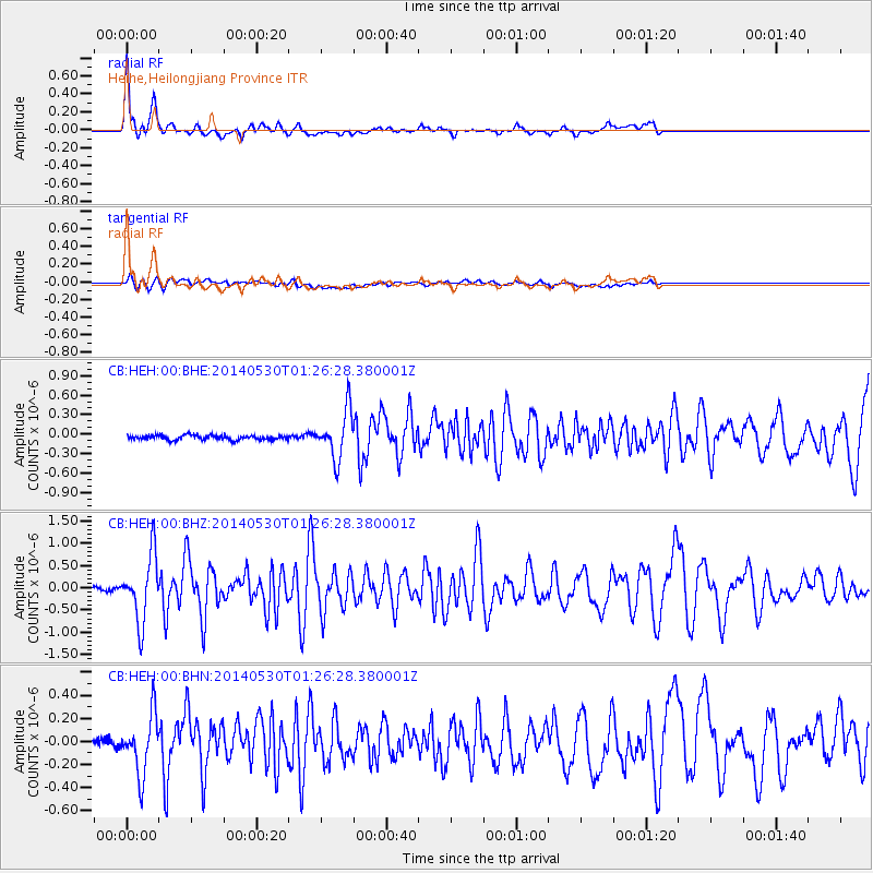
Signal To Noise
| Channel | StoN | STA | LTA |
| CB:HEH:00:BHZ:20140530T01:26:28.380001Z | 15.237748 | 7.3983574E-7 | 4.8552824E-8 |
| CB:HEH:00:BHN:20140530T01:26:28.380001Z | 6.944271 | 2.5515882E-7 | 3.6743785E-8 |
| CB:HEH:00:BHE:20140530T01:26:28.380001Z | 10.435551 | 3.693614E-7 | 3.5394528E-8 |
| Arrivals |
| Ps | 4.2 SECOND |
| PpPs | 11 SECOND |
| PsPs/PpSs | 15 SECOND |


