You are here: Home > Network List > KZ - Kazakhstan Network Stations List
> Station OTUK ORTAU, Kazakstan > Earthquake Result Viewer
OTUK ORTAU, Kazakstan - Earthquake Result Viewer
| Earthquake location: |
Myanmar-China Border Region |
| Earthquake latitude/longitude: |
25.0/97.9 |
| Earthquake time(UTC): |
2014/05/30 (150) 01:20:15 GMT |
| Earthquake Depth: |
10 km |
| Earthquake Magnitude: |
5.9 MB |
| Earthquake Catalog/Contributor: |
NEIC PDE/NEIC COMCAT |
|
| Network: |
KZ Kazakhstan Network |
| Station: |
OTUK ORTAU, Kazakstan |
| Lat/Lon: |
48.24 N/72.34 E |
| Elevation: |
750 m |
|
| Distance: |
30.7 deg |
| Az: |
325.665 deg |
| Baz: |
130.022 deg |
| Ray Param: |
0.07926022 |
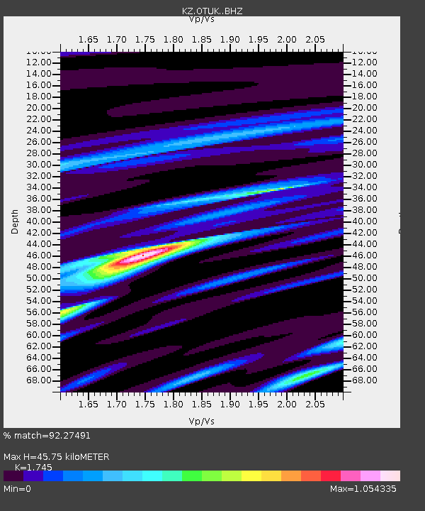
| Estimated Moho Depth: |
45.75 km |
| Estimated Crust Vp/Vs: |
1.75 |
| Assumed Crust Vp: |
6.571 km/s |
| Estimated Crust Vs: |
3.765 km/s |
| Estimated Crust Poisson's Ratio: |
0.26 |
|
| Radial Match: |
92.27491 % |
| Radial Bump: |
331 |
| Transverse Match: |
71.802025 % |
| Transverse Bump: |
400 |
| SOD ConfigId: |
3390531 |
| Insert Time: |
2019-04-12 01:49:49.510 +0000 |
| GWidth: |
2.5 |
| Max Bumps: |
400 |
| Tol: |
0.001 |
|

Signal To Noise
| Channel | StoN | STA | LTA |
| KZ:OTUK: :BHZ:20140530T01:25:55.275997Z | 16.982151 | 4.7673385E-7 | 2.8072641E-8 |
| KZ:OTUK: :BHN:20140530T01:25:55.275997Z | 4.326361 | 1.955774E-7 | 4.520598E-8 |
| KZ:OTUK: :BHE:20140530T01:25:55.275997Z | 3.5713465 | 2.1952609E-7 | 6.146872E-8 |
| Arrivals |
| Ps | 5.7 SECOND |
| PpPs | 18 SECOND |
| PsPs/PpSs | 23 SECOND |


