You are here: Home > Network List > TA - USArray Transportable Network (new EarthScope stations) Stations List
> Station L04D Klamath Falls, OR, USA > Earthquake Result Viewer
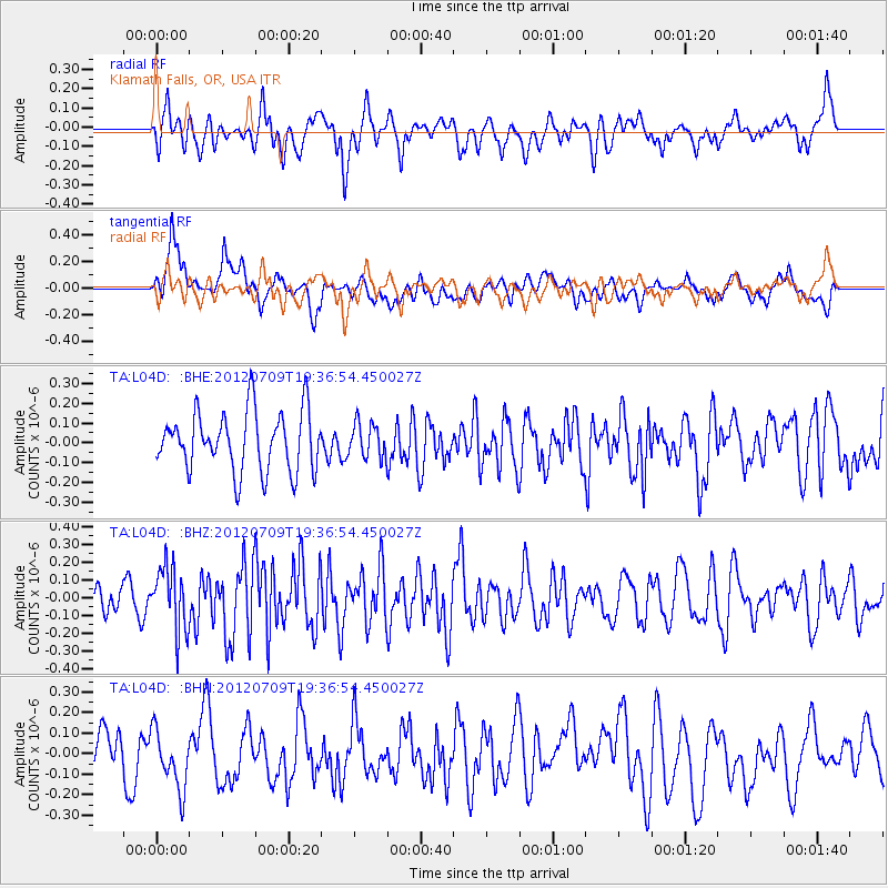
L04D Klamath Falls, OR, USA - Earthquake Result Viewer
*The percent match for this event was below the threshold and hence no stack was calculated.
| Earthquake location: |
Ryukyu Islands, Japan |
| Earthquake latitude/longitude: |
29.4/130.1 |
| Earthquake time(UTC): |
2012/07/09 (191) 19:25:07 GMT |
| Earthquake Depth: |
39 km |
| Earthquake Magnitude: |
5.6 MW, 5.1 MS, 5.1 MB, 5.5 MW |
| Earthquake Catalog/Contributor: |
WHDF/NEIC |
|
| Network: |
TA USArray Transportable Network (new EarthScope stations) |
| Station: |
L04D Klamath Falls, OR, USA |
| Lat/Lon: |
42.22 N/122.30 W |
| Elevation: |
1437 m |
|
| Distance: |
82.5 deg |
| Az: |
45.579 deg |
| Baz: |
302.95 deg |
| Ray Param: |
$rayparam |
*The percent match for this event was below the threshold and hence was not used in the summary stack. |
|
| Radial Match: |
57.53425 % |
| Radial Bump: |
400 |
| Transverse Match: |
59.839233 % |
| Transverse Bump: |
400 |
| SOD ConfigId: |
466652 |
| Insert Time: |
2013-02-21 03:22:12.044 +0000 |
| GWidth: |
2.5 |
| Max Bumps: |
400 |
| Tol: |
0.001 |
|
Signal To Noise
| Channel | StoN | STA | LTA |
| TA:L04D: :BHZ:20120709T19:36:54.450027Z | 1.6820633 | 1.7788017E-7 | 1.0575117E-7 |
| TA:L04D: :BHN:20120709T19:36:54.450027Z | 1.8429084 | 1.4996094E-7 | 8.1371894E-8 |
| TA:L04D: :BHE:20120709T19:36:54.450027Z | 0.57471067 | 8.658025E-8 | 1.5065015E-7 |
| Arrivals |
| Ps | |
| PpPs | |
| PsPs/PpSs | |


