You are here: Home > Network List > G - GEOSCOPE Stations List
> Station SSB Saint Sauveur Badole, France > Earthquake Result Viewer
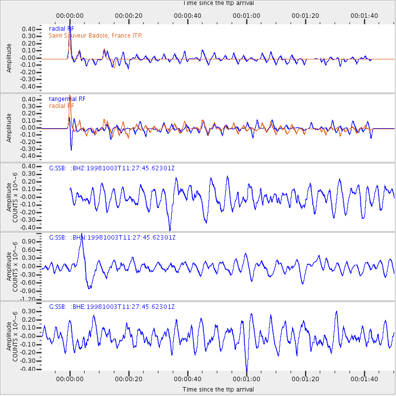
SSB Saint Sauveur Badole, France - Earthquake Result Viewer
*The percent match for this event was below the threshold and hence no stack was calculated.
| Earthquake location: |
Northwest Of Ryukyu Islands |
| Earthquake latitude/longitude: |
28.5/127.6 |
| Earthquake time(UTC): |
1998/10/03 (276) 11:15:42 GMT |
| Earthquake Depth: |
227 km |
| Earthquake Magnitude: |
5.6 MB, 6.1 UNKNOWN, 6.1 MW |
| Earthquake Catalog/Contributor: |
WHDF/NEIC |
|
| Network: |
G GEOSCOPE |
| Station: |
SSB Saint Sauveur Badole, France |
| Lat/Lon: |
45.28 N/4.54 E |
| Elevation: |
700 m |
|
| Distance: |
90.2 deg |
| Az: |
323.726 deg |
| Baz: |
47.52 deg |
| Ray Param: |
$rayparam |
*The percent match for this event was below the threshold and hence was not used in the summary stack. |
|
| Radial Match: |
77.89864 % |
| Radial Bump: |
347 |
| Transverse Match: |
53.98433 % |
| Transverse Bump: |
400 |
| SOD ConfigId: |
4480 |
| Insert Time: |
2010-02-27 00:17:52.101 +0000 |
| GWidth: |
2.5 |
| Max Bumps: |
400 |
| Tol: |
0.001 |
|
Signal To Noise
| Channel | StoN | STA | LTA |
| G:SSB: :BHN:19981003T11:27:45.62301Z | 4.115405 | 4.866273E-7 | 1.1824531E-7 |
| G:SSB: :BHE:19981003T11:27:45.62301Z | 1.0146246 | 1.19207755E-7 | 1.1748952E-7 |
| G:SSB: :BHZ:19981003T11:27:45.62301Z | 2.0602462 | 1.7843533E-7 | 8.6608736E-8 |
| Arrivals |
| Ps | |
| PpPs | |
| PsPs/PpSs | |


