You are here: Home > Network List > CN - Canadian National Seismograph Network Stations List
> Station INK INUVIK, NT > Earthquake Result Viewer
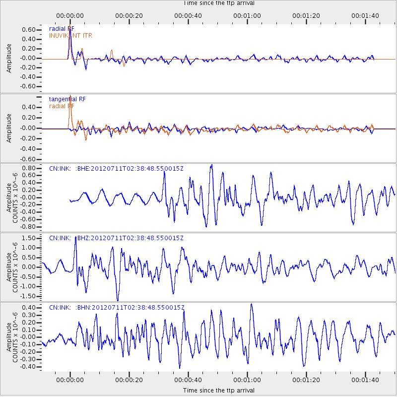
INK INUVIK, NT - Earthquake Result Viewer
*The percent match for this event was below the threshold and hence no stack was calculated.
| Earthquake location: |
Kuril Islands |
| Earthquake latitude/longitude: |
45.4/151.4 |
| Earthquake time(UTC): |
2012/07/11 (193) 02:31:16 GMT |
| Earthquake Depth: |
10 km |
| Earthquake Magnitude: |
5.6 MB, 5.5 MS, 5.7 MW, 5.7 MW |
| Earthquake Catalog/Contributor: |
WHDF/NEIC |
|
| Network: |
CN Canadian National Seismograph Network |
| Station: |
INK INUVIK, NT |
| Lat/Lon: |
68.31 N/133.53 W |
| Elevation: |
44 m |
|
| Distance: |
43.4 deg |
| Az: |
31.509 deg |
| Baz: |
277.956 deg |
| Ray Param: |
$rayparam |
*The percent match for this event was below the threshold and hence was not used in the summary stack. |
|
| Radial Match: |
78.35134 % |
| Radial Bump: |
385 |
| Transverse Match: |
70.11796 % |
| Transverse Bump: |
400 |
| SOD ConfigId: |
466652 |
| Insert Time: |
2013-02-21 13:57:03.176 +0000 |
| GWidth: |
2.5 |
| Max Bumps: |
400 |
| Tol: |
0.001 |
|
Signal To Noise
| Channel | StoN | STA | LTA |
| CN:INK: :BHZ:20120711T02:38:48.550015Z | 4.3308253 | 5.7088056E-7 | 1.3181796E-7 |
| CN:INK: :BHN:20120711T02:38:48.550015Z | 1.1519911 | 9.49555E-8 | 8.2427285E-8 |
| CN:INK: :BHE:20120711T02:38:48.550015Z | 2.450913 | 2.7252324E-7 | 1.1119254E-7 |
| Arrivals |
| Ps | |
| PpPs | |
| PsPs/PpSs | |


