You are here: Home > Network List > KC - Central Asian Seismic Network of CAIAG Stations List
> Station TARG Taragai, Kyrgyzstan > Earthquake Result Viewer
TARG Taragai, Kyrgyzstan - Earthquake Result Viewer
| Earthquake location: |
Kuril Islands |
| Earthquake latitude/longitude: |
45.4/151.4 |
| Earthquake time(UTC): |
2012/07/11 (193) 02:31:16 GMT |
| Earthquake Depth: |
10 km |
| Earthquake Magnitude: |
5.6 MB, 5.5 MS, 5.7 MW, 5.7 MW |
| Earthquake Catalog/Contributor: |
WHDF/NEIC |
|
| Network: |
KC Central Asian Seismic Network of CAIAG |
| Station: |
TARG Taragai, Kyrgyzstan |
| Lat/Lon: |
41.73 N/77.80 E |
| Elevation: |
3530 m |
|
| Distance: |
51.7 deg |
| Az: |
293.843 deg |
| Baz: |
59.419 deg |
| Ray Param: |
0.06722018 |
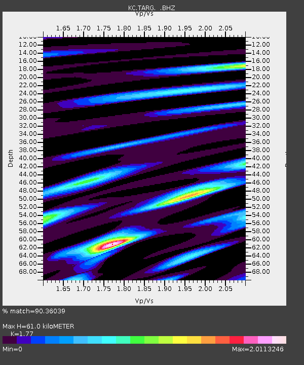
| Estimated Moho Depth: |
61.0 km |
| Estimated Crust Vp/Vs: |
1.77 |
| Assumed Crust Vp: |
6.491 km/s |
| Estimated Crust Vs: |
3.667 km/s |
| Estimated Crust Poisson's Ratio: |
0.27 |
|
| Radial Match: |
90.36039 % |
| Radial Bump: |
400 |
| Transverse Match: |
88.899414 % |
| Transverse Bump: |
400 |
| SOD ConfigId: |
466652 |
| Insert Time: |
2013-02-21 14:01:42.912 +0000 |
| GWidth: |
2.5 |
| Max Bumps: |
400 |
| Tol: |
0.001 |
|

Signal To Noise
| Channel | StoN | STA | LTA |
| KC:TARG: :BHZ:20120711T02:39:53.094998Z | 15.282709 | 9.480019E-7 | 6.203101E-8 |
| KC:TARG: :BHN:20120711T02:39:53.094998Z | 12.555549 | 5.071146E-7 | 4.038968E-8 |
| KC:TARG: :BHE:20120711T02:39:53.094998Z | 8.123529 | 3.270516E-7 | 4.0259792E-8 |
| Arrivals |
| Ps | 7.7 SECOND |
| PpPs | 25 SECOND |
| PsPs/PpSs | 32 SECOND |


