You are here: Home > Network List > G - GEOSCOPE Stations List
> Station SSB Saint Sauveur Badole, France > Earthquake Result Viewer
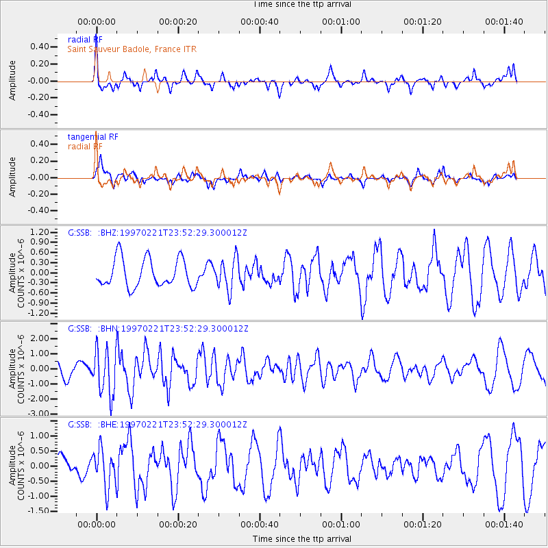
SSB Saint Sauveur Badole, France - Earthquake Result Viewer
*The percent match for this event was below the threshold and hence no stack was calculated.
| Earthquake location: |
East Of Kuril Islands |
| Earthquake latitude/longitude: |
43.8/149.2 |
| Earthquake time(UTC): |
1997/02/21 (052) 23:40:24 GMT |
| Earthquake Depth: |
33 km |
| Earthquake Magnitude: |
6.1 MB, 5.6 MS, 6.1 UNKNOWN, 6.1 MW |
| Earthquake Catalog/Contributor: |
WHDF/NEIC |
|
| Network: |
G GEOSCOPE |
| Station: |
SSB Saint Sauveur Badole, France |
| Lat/Lon: |
45.28 N/4.54 E |
| Elevation: |
700 m |
|
| Distance: |
85.9 deg |
| Az: |
335.807 deg |
| Baz: |
24.839 deg |
| Ray Param: |
$rayparam |
*The percent match for this event was below the threshold and hence was not used in the summary stack. |
|
| Radial Match: |
73.45982 % |
| Radial Bump: |
314 |
| Transverse Match: |
75.367874 % |
| Transverse Bump: |
400 |
| SOD ConfigId: |
4480 |
| Insert Time: |
2010-02-27 00:18:06.942 +0000 |
| GWidth: |
2.5 |
| Max Bumps: |
400 |
| Tol: |
0.001 |
|
Signal To Noise
| Channel | StoN | STA | LTA |
| G:SSB: :BHN:19970221T23:52:29.300012Z | 2.367597 | 1.5558654E-6 | 6.5714954E-7 |
| G:SSB: :BHE:19970221T23:52:29.300012Z | 1.3845792 | 6.562893E-7 | 4.7399908E-7 |
| G:SSB: :BHZ:19970221T23:52:29.300012Z | 1.1248635 | 4.6840367E-7 | 4.1640934E-7 |
| Arrivals |
| Ps | |
| PpPs | |
| PsPs/PpSs | |


