You are here: Home > Network List > G - GEOSCOPE Stations List
> Station SSB Saint Sauveur Badole, France > Earthquake Result Viewer
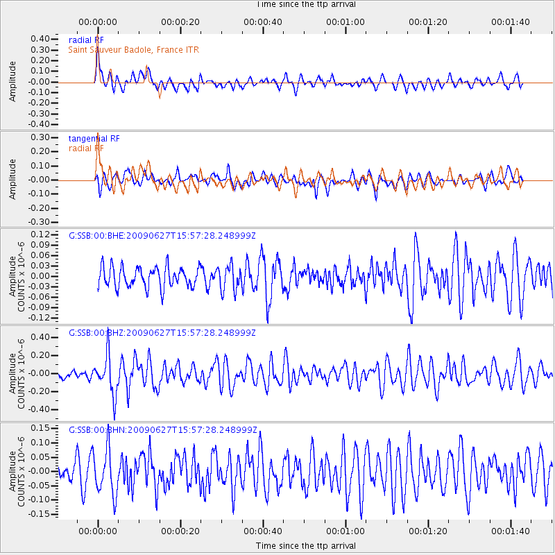
SSB Saint Sauveur Badole, France - Earthquake Result Viewer
*The percent match for this event was below the threshold and hence no stack was calculated.
| Earthquake location: |
Southern Mid-Atlantic Ridge |
| Earthquake latitude/longitude: |
-33.2/-15.9 |
| Earthquake time(UTC): |
2009/06/27 (178) 15:45:49 GMT |
| Earthquake Depth: |
13 km |
| Earthquake Magnitude: |
5.6 MB, 5.3 MS, 5.6 MW |
| Earthquake Catalog/Contributor: |
WHDF/NEIC |
|
| Network: |
G GEOSCOPE |
| Station: |
SSB Saint Sauveur Badole, France |
| Lat/Lon: |
45.28 N/4.54 E |
| Elevation: |
700 m |
|
| Distance: |
80.3 deg |
| Az: |
14.512 deg |
| Baz: |
197.312 deg |
| Ray Param: |
$rayparam |
*The percent match for this event was below the threshold and hence was not used in the summary stack. |
|
| Radial Match: |
68.26305 % |
| Radial Bump: |
400 |
| Transverse Match: |
71.364105 % |
| Transverse Bump: |
400 |
| SOD ConfigId: |
2648 |
| Insert Time: |
2010-02-27 00:18:08.764 +0000 |
| GWidth: |
2.5 |
| Max Bumps: |
400 |
| Tol: |
0.001 |
|
Signal To Noise
| Channel | StoN | STA | LTA |
| G:SSB:00:BHZ:20090627T15:57:28.248999Z | 4.8743954 | 2.220681E-7 | 4.555808E-8 |
| G:SSB:00:BHN:20090627T15:57:28.248999Z | 3.0589232 | 7.947235E-8 | 2.5980498E-8 |
| G:SSB:00:BHE:20090627T15:57:28.248999Z | 1.2506131 | 3.6420506E-8 | 2.912212E-8 |
| Arrivals |
| Ps | |
| PpPs | |
| PsPs/PpSs | |


