You are here: Home > Network List > TA - USArray Transportable Network (new EarthScope stations) Stations List
> Station Y46A Houston, MS, USA > Earthquake Result Viewer
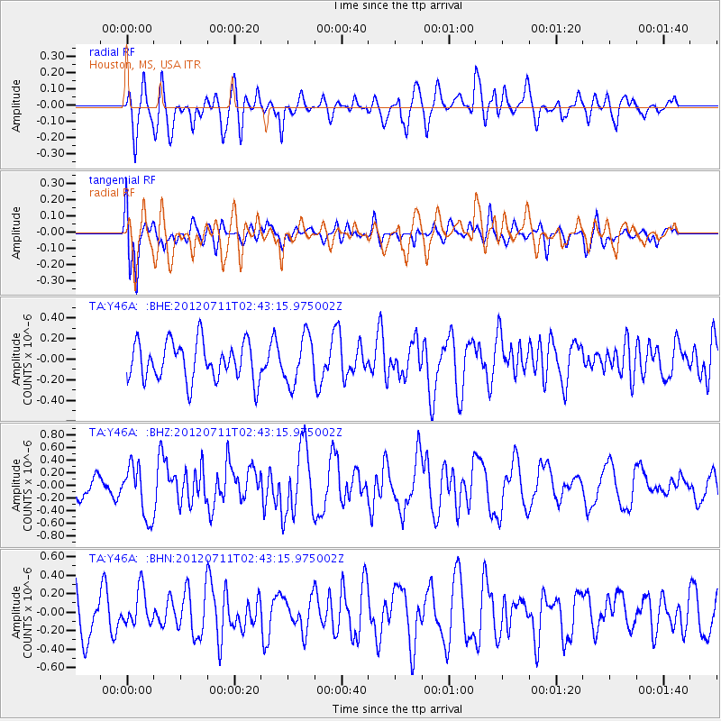
Y46A Houston, MS, USA - Earthquake Result Viewer
*The percent match for this event was below the threshold and hence no stack was calculated.
| Earthquake location: |
Kuril Islands |
| Earthquake latitude/longitude: |
45.4/151.4 |
| Earthquake time(UTC): |
2012/07/11 (193) 02:31:16 GMT |
| Earthquake Depth: |
10 km |
| Earthquake Magnitude: |
5.6 MB, 5.5 MS, 5.7 MW, 5.7 MW |
| Earthquake Catalog/Contributor: |
WHDF/NEIC |
|
| Network: |
TA USArray Transportable Network (new EarthScope stations) |
| Station: |
Y46A Houston, MS, USA |
| Lat/Lon: |
33.88 N/88.86 W |
| Elevation: |
109 m |
|
| Distance: |
84.1 deg |
| Az: |
46.583 deg |
| Baz: |
322.037 deg |
| Ray Param: |
$rayparam |
*The percent match for this event was below the threshold and hence was not used in the summary stack. |
|
| Radial Match: |
62.528965 % |
| Radial Bump: |
400 |
| Transverse Match: |
66.935844 % |
| Transverse Bump: |
400 |
| SOD ConfigId: |
466652 |
| Insert Time: |
2013-02-21 14:18:26.880 +0000 |
| GWidth: |
2.5 |
| Max Bumps: |
400 |
| Tol: |
0.001 |
|
Signal To Noise
| Channel | StoN | STA | LTA |
| TA:Y46A: :BHZ:20120711T02:43:15.975002Z | 2.558974 | 4.0934063E-7 | 1.599628E-7 |
| TA:Y46A: :BHN:20120711T02:43:15.975002Z | 0.8273094 | 1.9536681E-7 | 2.361472E-7 |
| TA:Y46A: :BHE:20120711T02:43:15.975002Z | 1.2444503 | 2.31095E-7 | 1.8570046E-7 |
| Arrivals |
| Ps | |
| PpPs | |
| PsPs/PpSs | |


