You are here: Home > Network List > TA - USArray Transportable Network (new EarthScope stations) Stations List
> Station TOLK Toolik Lake Research Station, AK, USA > Earthquake Result Viewer
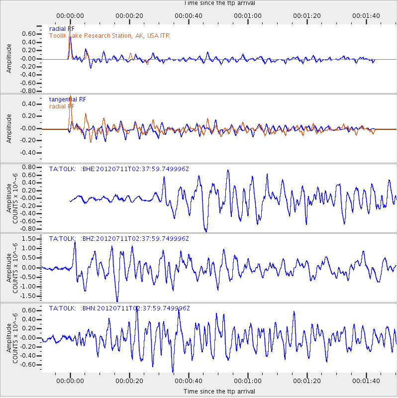
TOLK Toolik Lake Research Station, AK, USA - Earthquake Result Viewer

| Earthquake location: |
Kuril Islands |
| Earthquake latitude/longitude: |
45.4/151.4 |
| Earthquake time(UTC): |
2012/07/11 (193) 02:31:16 GMT |
| Earthquake Depth: |
10 km |
| Earthquake Magnitude: |
5.6 MB, 5.5 MS, 5.7 MW, 5.7 MW |
| Earthquake Catalog/Contributor: |
WHDF/NEIC |
|
| Network: |
TA USArray Transportable Network (new EarthScope stations) |
| Station: |
TOLK Toolik Lake Research Station, AK, USA |
| Lat/Lon: |
68.64 N/149.57 W |
| Elevation: |
760 m |
|
| Distance: |
37.5 deg |
| Az: |
31.047 deg |
| Baz: |
262.677 deg |
| Ray Param: |
0.07609712 |
| Estimated Moho Depth: |
12.25 km |
| Estimated Crust Vp/Vs: |
1.92 |
| Assumed Crust Vp: |
6.316 km/s |
| Estimated Crust Vs: |
3.294 km/s |
| Estimated Crust Poisson's Ratio: |
0.31 |
|
| Radial Match: |
85.41754 % |
| Radial Bump: |
400 |
| Transverse Match: |
78.60849 % |
| Transverse Bump: |
400 |
| SOD ConfigId: |
466652 |
| Insert Time: |
2013-02-21 14:22:10.485 +0000 |
| GWidth: |
2.5 |
| Max Bumps: |
400 |
| Tol: |
0.001 |
|
Signal To Noise
| Channel | StoN | STA | LTA |
| TA:TOLK: :BHZ:20120711T02:37:59.749996Z | 7.313434 | 5.928244E-7 | 8.1059646E-8 |
| TA:TOLK: :BHN:20120711T02:37:59.749996Z | 1.2654656 | 7.3336665E-8 | 5.795232E-8 |
| TA:TOLK: :BHE:20120711T02:37:59.749996Z | 4.5534525 | 2.2475415E-7 | 4.9359063E-8 |
| Arrivals |
| Ps | 1.9 SECOND |
| PpPs | 5.3 SECOND |
| PsPs/PpSs | 7.2 SECOND |


