You are here: Home > Network List > TA - USArray Transportable Network (new EarthScope stations) Stations List
> Station F41A Wisconsin Rapids, WI, USA > Earthquake Result Viewer
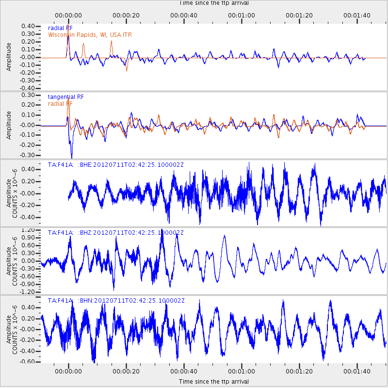
F41A Wisconsin Rapids, WI, USA - Earthquake Result Viewer
*The percent match for this event was below the threshold and hence no stack was calculated.
| Earthquake location: |
Kuril Islands |
| Earthquake latitude/longitude: |
45.4/151.4 |
| Earthquake time(UTC): |
2012/07/11 (193) 02:31:16 GMT |
| Earthquake Depth: |
10 km |
| Earthquake Magnitude: |
5.6 MB, 5.5 MS, 5.7 MW, 5.7 MW |
| Earthquake Catalog/Contributor: |
WHDF/NEIC |
|
| Network: |
TA USArray Transportable Network (new EarthScope stations) |
| Station: |
F41A Wisconsin Rapids, WI, USA |
| Lat/Lon: |
45.74 N/89.10 W |
| Elevation: |
509 m |
|
| Distance: |
74.7 deg |
| Az: |
39.206 deg |
| Baz: |
320.514 deg |
| Ray Param: |
$rayparam |
*The percent match for this event was below the threshold and hence was not used in the summary stack. |
|
| Radial Match: |
63.380356 % |
| Radial Bump: |
400 |
| Transverse Match: |
69.75442 % |
| Transverse Bump: |
400 |
| SOD ConfigId: |
466652 |
| Insert Time: |
2013-02-21 14:23:35.080 +0000 |
| GWidth: |
2.5 |
| Max Bumps: |
400 |
| Tol: |
0.001 |
|
Signal To Noise
| Channel | StoN | STA | LTA |
| TA:F41A: :BHZ:20120711T02:42:25.100002Z | 2.8310626 | 4.7266715E-7 | 1.669575E-7 |
| TA:F41A: :BHN:20120711T02:42:25.100002Z | 1.6272722 | 2.0453452E-7 | 1.2569164E-7 |
| TA:F41A: :BHE:20120711T02:42:25.100002Z | 1.5744879 | 1.6168464E-7 | 1.026903E-7 |
| Arrivals |
| Ps | |
| PpPs | |
| PsPs/PpSs | |


