You are here: Home > Network List > TA - USArray Transportable Network (new EarthScope stations) Stations List
> Station E43A Lone Tree Farm, Eben Junction, MI, USA > Earthquake Result Viewer
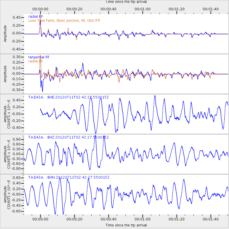
E43A Lone Tree Farm, Eben Junction, MI, USA - Earthquake Result Viewer
*The percent match for this event was below the threshold and hence no stack was calculated.
| Earthquake location: |
Kuril Islands |
| Earthquake latitude/longitude: |
45.4/151.4 |
| Earthquake time(UTC): |
2012/07/11 (193) 02:31:16 GMT |
| Earthquake Depth: |
10 km |
| Earthquake Magnitude: |
5.6 MB, 5.5 MS, 5.7 MW, 5.7 MW |
| Earthquake Catalog/Contributor: |
WHDF/NEIC |
|
| Network: |
TA USArray Transportable Network (new EarthScope stations) |
| Station: |
E43A Lone Tree Farm, Eben Junction, MI, USA |
| Lat/Lon: |
46.38 N/87.00 W |
| Elevation: |
303 m |
|
| Distance: |
75.1 deg |
| Az: |
37.608 deg |
| Baz: |
321.612 deg |
| Ray Param: |
$rayparam |
*The percent match for this event was below the threshold and hence was not used in the summary stack. |
|
| Radial Match: |
54.10238 % |
| Radial Bump: |
367 |
| Transverse Match: |
59.944633 % |
| Transverse Bump: |
370 |
| SOD ConfigId: |
466652 |
| Insert Time: |
2013-02-21 14:23:59.377 +0000 |
| GWidth: |
2.5 |
| Max Bumps: |
400 |
| Tol: |
0.001 |
|
Signal To Noise
| Channel | StoN | STA | LTA |
| TA:E43A: :BHZ:20120711T02:42:27.550015Z | 2.3664541 | 4.3232717E-7 | 1.8268986E-7 |
| TA:E43A: :BHN:20120711T02:42:27.550015Z | 1.9526565 | 2.7674338E-7 | 1.417266E-7 |
| TA:E43A: :BHE:20120711T02:42:27.550015Z | 3.407546 | 3.6994973E-7 | 1.0856778E-7 |
| Arrivals |
| Ps | |
| PpPs | |
| PsPs/PpSs | |


