You are here: Home > Network List > TA - USArray Transportable Network (new EarthScope stations) Stations List
> Station X49A Woodville, AR, USA > Earthquake Result Viewer
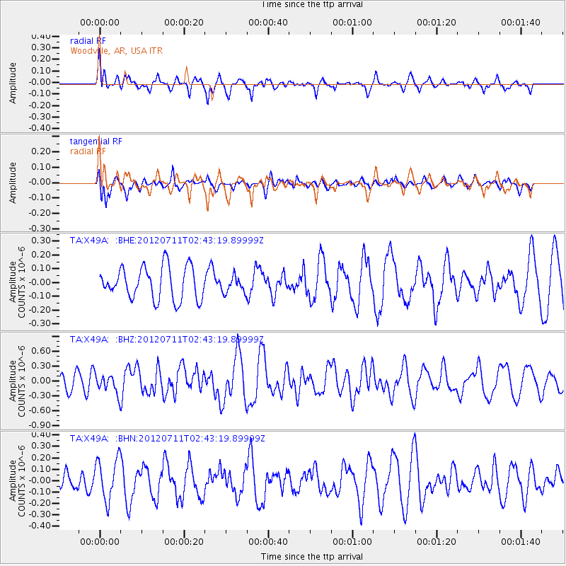
X49A Woodville, AR, USA - Earthquake Result Viewer
*The percent match for this event was below the threshold and hence no stack was calculated.
| Earthquake location: |
Kuril Islands |
| Earthquake latitude/longitude: |
45.4/151.4 |
| Earthquake time(UTC): |
2012/07/11 (193) 02:31:16 GMT |
| Earthquake Depth: |
10 km |
| Earthquake Magnitude: |
5.6 MB, 5.5 MS, 5.7 MW, 5.7 MW |
| Earthquake Catalog/Contributor: |
WHDF/NEIC |
|
| Network: |
TA USArray Transportable Network (new EarthScope stations) |
| Station: |
X49A Woodville, AR, USA |
| Lat/Lon: |
34.51 N/86.33 W |
| Elevation: |
182 m |
|
| Distance: |
84.8 deg |
| Az: |
44.524 deg |
| Baz: |
323.255 deg |
| Ray Param: |
$rayparam |
*The percent match for this event was below the threshold and hence was not used in the summary stack. |
|
| Radial Match: |
73.19666 % |
| Radial Bump: |
400 |
| Transverse Match: |
59.34257 % |
| Transverse Bump: |
400 |
| SOD ConfigId: |
466652 |
| Insert Time: |
2013-02-21 14:25:22.845 +0000 |
| GWidth: |
2.5 |
| Max Bumps: |
400 |
| Tol: |
0.001 |
|
Signal To Noise
| Channel | StoN | STA | LTA |
| TA:X49A: :BHZ:20120711T02:43:19.89999Z | 1.0188087 | 1.8726288E-7 | 1.8380572E-7 |
| TA:X49A: :BHN:20120711T02:43:19.89999Z | 2.2582645 | 1.8734303E-7 | 8.2958856E-8 |
| TA:X49A: :BHE:20120711T02:43:19.89999Z | 0.5123189 | 6.0256305E-8 | 1.1761483E-7 |
| Arrivals |
| Ps | |
| PpPs | |
| PsPs/PpSs | |


