You are here: Home > Network List > DK - Danish Seismological Network Stations List
> Station DBG Daneborg, Greenland > Earthquake Result Viewer
DBG Daneborg, Greenland - Earthquake Result Viewer
| Earthquake location: |
Kuril Islands |
| Earthquake latitude/longitude: |
45.5/151.7 |
| Earthquake time(UTC): |
2012/07/12 (194) 12:51:58 GMT |
| Earthquake Depth: |
12 km |
| Earthquake Magnitude: |
5.5 MB, 5.6 MS, 5.8 MW, 5.7 MW |
| Earthquake Catalog/Contributor: |
WHDF/NEIC |
|
| Network: |
DK Danish Seismological Network |
| Station: |
DBG Daneborg, Greenland |
| Lat/Lon: |
74.31 N/20.22 W |
| Elevation: |
1.0 m |
|
| Distance: |
60.4 deg |
| Az: |
357.467 deg |
| Baz: |
6.562 deg |
| Ray Param: |
0.06154809 |
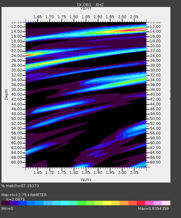
| Estimated Moho Depth: |
12.75 km |
| Estimated Crust Vp/Vs: |
2.10 |
| Assumed Crust Vp: |
6.459 km/s |
| Estimated Crust Vs: |
3.08 km/s |
| Estimated Crust Poisson's Ratio: |
0.35 |
|
| Radial Match: |
87.35373 % |
| Radial Bump: |
399 |
| Transverse Match: |
66.42628 % |
| Transverse Bump: |
400 |
| SOD ConfigId: |
466652 |
| Insert Time: |
2013-02-21 16:59:36.936 +0000 |
| GWidth: |
2.5 |
| Max Bumps: |
400 |
| Tol: |
0.001 |
|

Signal To Noise
| Channel | StoN | STA | LTA |
| DK:DBG: :BHZ:20120712T13:01:36.899978Z | 11.627266 | 8.7175107E-7 | 7.497472E-8 |
| DK:DBG: :BHN:20120712T13:01:36.899978Z | 7.3603835 | 4.2609105E-7 | 5.7889793E-8 |
| DK:DBG: :BHE:20120712T13:01:36.899978Z | 1.731456 | 1.3560803E-7 | 7.832023E-8 |
| Arrivals |
| Ps | 2.3 SECOND |
| PpPs | 5.9 SECOND |
| PsPs/PpSs | 8.1 SECOND |


