You are here: Home > Network List > IC - New China Digital Seismograph Network Stations List
> Station WMQ Urumqi, Xinjiang Province, China > Earthquake Result Viewer
WMQ Urumqi, Xinjiang Province, China - Earthquake Result Viewer

| Earthquake location: |
Kuril Islands |
| Earthquake latitude/longitude: |
45.5/151.7 |
| Earthquake time(UTC): |
2012/07/12 (194) 12:51:58 GMT |
| Earthquake Depth: |
12 km |
| Earthquake Magnitude: |
5.5 MB, 5.6 MS, 5.8 MW, 5.7 MW |
| Earthquake Catalog/Contributor: |
WHDF/NEIC |
|
| Network: |
IC New China Digital Seismograph Network |
| Station: |
WMQ Urumqi, Xinjiang Province, China |
| Lat/Lon: |
43.81 N/87.70 E |
| Elevation: |
850 m |
|
| Distance: |
44.5 deg |
| Az: |
291.779 deg |
| Baz: |
64.548 deg |
| Ray Param: |
0.0718973 |
| Estimated Moho Depth: |
39.5 km |
| Estimated Crust Vp/Vs: |
2.05 |
| Assumed Crust Vp: |
6.242 km/s |
| Estimated Crust Vs: |
3.041 km/s |
| Estimated Crust Poisson's Ratio: |
0.34 |
|
| Radial Match: |
94.748436 % |
| Radial Bump: |
400 |
| Transverse Match: |
89.0172 % |
| Transverse Bump: |
400 |
| SOD ConfigId: |
466652 |
| Insert Time: |
2013-02-21 17:00:09.150 +0000 |
| GWidth: |
2.5 |
| Max Bumps: |
400 |
| Tol: |
0.001 |
|
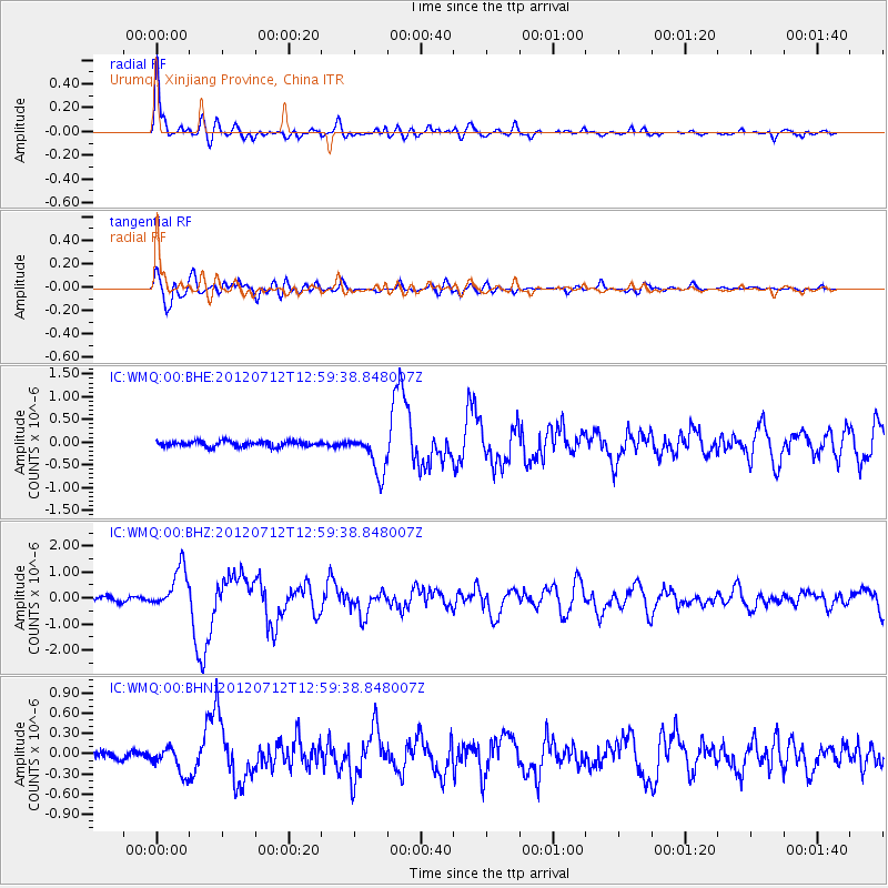
Signal To Noise
| Channel | StoN | STA | LTA |
| IC:WMQ:00:BHZ:20120712T12:59:38.848007Z | 9.276367 | 8.0082356E-7 | 8.632944E-8 |
| IC:WMQ:00:BHN:20120712T12:59:38.848007Z | 3.7437112 | 1.9454511E-7 | 5.196584E-8 |
| IC:WMQ:00:BHE:20120712T12:59:38.848007Z | 7.2117505 | 4.413969E-7 | 6.120524E-8 |
| Arrivals |
| Ps | 7.0 SECOND |
| PpPs | 18 SECOND |
| PsPs/PpSs | 25 SECOND |


