You are here: Home > Network List > PL - Polish Seismological Network Stations List
> Station KSP KSIAZ, POLAND > Earthquake Result Viewer
KSP KSIAZ, POLAND - Earthquake Result Viewer
| Earthquake location: |
Kuril Islands |
| Earthquake latitude/longitude: |
45.5/151.7 |
| Earthquake time(UTC): |
2012/07/12 (194) 12:51:58 GMT |
| Earthquake Depth: |
12 km |
| Earthquake Magnitude: |
5.5 MB, 5.6 MS, 5.8 MW, 5.7 MW |
| Earthquake Catalog/Contributor: |
WHDF/NEIC |
|
| Network: |
PL Polish Seismological Network |
| Station: |
KSP KSIAZ, POLAND |
| Lat/Lon: |
50.84 N/16.29 E |
| Elevation: |
353 m |
|
| Distance: |
76.6 deg |
| Az: |
332.752 deg |
| Baz: |
30.552 deg |
| Ray Param: |
0.050879795 |
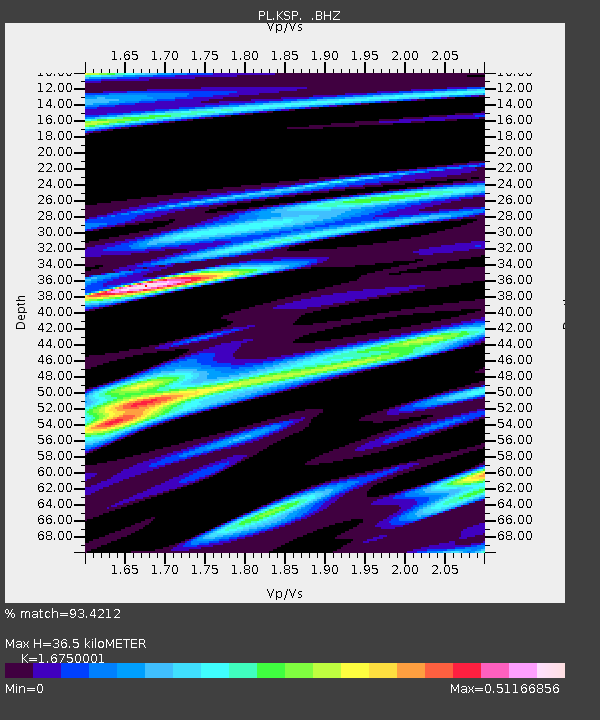
| Estimated Moho Depth: |
36.5 km |
| Estimated Crust Vp/Vs: |
1.68 |
| Assumed Crust Vp: |
6.194 km/s |
| Estimated Crust Vs: |
3.698 km/s |
| Estimated Crust Poisson's Ratio: |
0.22 |
|
| Radial Match: |
93.4212 % |
| Radial Bump: |
400 |
| Transverse Match: |
67.273796 % |
| Transverse Bump: |
400 |
| SOD ConfigId: |
467763 |
| Insert Time: |
2013-02-21 17:13:18.638 +0000 |
| GWidth: |
2.5 |
| Max Bumps: |
400 |
| Tol: |
0.001 |
|

Signal To Noise
| Channel | StoN | STA | LTA |
| PL:KSP: :BHZ:20120712T13:03:17.838027Z | 7.0245953 | 5.2058414E-7 | 7.4108776E-8 |
| PL:KSP: :BHN:20120712T13:03:17.839004Z | 4.773236 | 2.4762136E-7 | 5.1877038E-8 |
| PL:KSP: :BHE:20120712T13:03:17.838027Z | 1.5295901 | 1.0697898E-7 | 6.993963E-8 |
| Arrivals |
| Ps | 4.1 SECOND |
| PpPs | 15 SECOND |
| PsPs/PpSs | 19 SECOND |


