You are here: Home > Network List > TA - USArray Transportable Network (new EarthScope stations) Stations List
> Station 147A Livingston, AL, USA > Earthquake Result Viewer
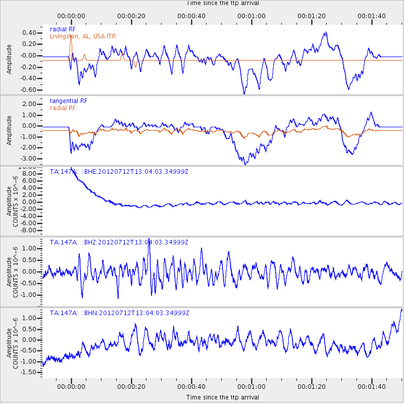
147A Livingston, AL, USA - Earthquake Result Viewer
*The percent match for this event was below the threshold and hence no stack was calculated.
| Earthquake location: |
Kuril Islands |
| Earthquake latitude/longitude: |
45.5/151.7 |
| Earthquake time(UTC): |
2012/07/12 (194) 12:51:58 GMT |
| Earthquake Depth: |
12 km |
| Earthquake Magnitude: |
5.5 MB, 5.6 MS, 5.8 MW, 5.7 MW |
| Earthquake Catalog/Contributor: |
WHDF/NEIC |
|
| Network: |
TA USArray Transportable Network (new EarthScope stations) |
| Station: |
147A Livingston, AL, USA |
| Lat/Lon: |
32.67 N/88.27 W |
| Elevation: |
57 m |
|
| Distance: |
85.2 deg |
| Az: |
47.099 deg |
| Baz: |
322.311 deg |
| Ray Param: |
$rayparam |
*The percent match for this event was below the threshold and hence was not used in the summary stack. |
|
| Radial Match: |
35.149204 % |
| Radial Bump: |
400 |
| Transverse Match: |
23.150919 % |
| Transverse Bump: |
400 |
| SOD ConfigId: |
467763 |
| Insert Time: |
2013-02-21 17:23:53.810 +0000 |
| GWidth: |
2.5 |
| Max Bumps: |
400 |
| Tol: |
0.001 |
|
Signal To Noise
| Channel | StoN | STA | LTA |
| TA:147A: :BHZ:20120712T13:04:03.34999Z | 2.9395452 | 3.984653E-7 | 1.3555338E-7 |
| TA:147A: :BHN:20120712T13:04:03.34999Z | 0.8277726 | 2.4919175E-6 | 3.0103888E-6 |
| TA:147A: :BHE:20120712T13:04:03.34999Z | 0.8201211 | 2.4844398E-6 | 3.0293572E-6 |
| Arrivals |
| Ps | |
| PpPs | |
| PsPs/PpSs | |


