You are here: Home > Network List > TA - USArray Transportable Network (new EarthScope stations) Stations List
> Station P39B Salisbury, MO, USA > Earthquake Result Viewer
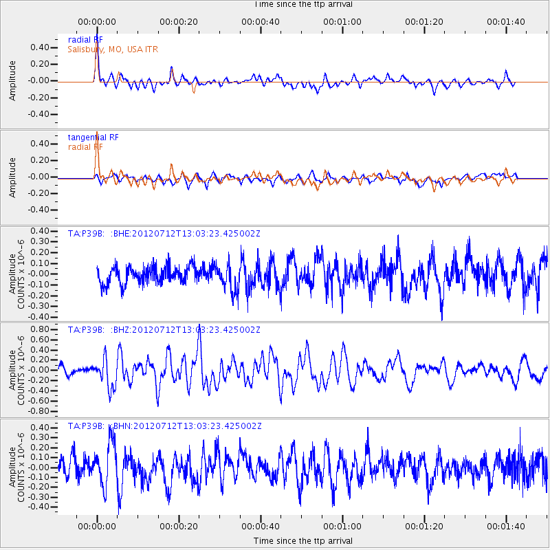
P39B Salisbury, MO, USA - Earthquake Result Viewer
*The percent match for this event was below the threshold and hence no stack was calculated.
| Earthquake location: |
Kuril Islands |
| Earthquake latitude/longitude: |
45.5/151.7 |
| Earthquake time(UTC): |
2012/07/12 (194) 12:51:58 GMT |
| Earthquake Depth: |
12 km |
| Earthquake Magnitude: |
5.5 MB, 5.6 MS, 5.8 MW, 5.7 MW |
| Earthquake Catalog/Contributor: |
WHDF/NEIC |
|
| Network: |
TA USArray Transportable Network (new EarthScope stations) |
| Station: |
P39B Salisbury, MO, USA |
| Lat/Lon: |
39.49 N/92.75 W |
| Elevation: |
226 m |
|
| Distance: |
77.6 deg |
| Az: |
45.615 deg |
| Baz: |
319.454 deg |
| Ray Param: |
$rayparam |
*The percent match for this event was below the threshold and hence was not used in the summary stack. |
|
| Radial Match: |
71.19722 % |
| Radial Bump: |
400 |
| Transverse Match: |
62.972775 % |
| Transverse Bump: |
400 |
| SOD ConfigId: |
467763 |
| Insert Time: |
2013-02-21 17:24:29.246 +0000 |
| GWidth: |
2.5 |
| Max Bumps: |
400 |
| Tol: |
0.001 |
|
Signal To Noise
| Channel | StoN | STA | LTA |
| TA:P39B: :BHZ:20120712T13:03:23.425002Z | 2.6249478 | 2.8160787E-7 | 1.0728132E-7 |
| TA:P39B: :BHN:20120712T13:03:23.425002Z | 2.2003984 | 2.1747941E-7 | 9.883638E-8 |
| TA:P39B: :BHE:20120712T13:03:23.425002Z | 1.5823109 | 1.2483153E-7 | 7.889191E-8 |
| Arrivals |
| Ps | |
| PpPs | |
| PsPs/PpSs | |


