You are here: Home > Network List > TA - USArray Transportable Network (new EarthScope stations) Stations List
> Station L41A Preston, IA, USA > Earthquake Result Viewer
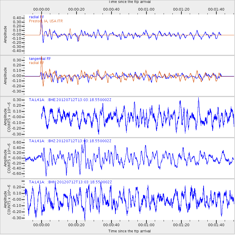
L41A Preston, IA, USA - Earthquake Result Viewer
*The percent match for this event was below the threshold and hence no stack was calculated.
| Earthquake location: |
Kuril Islands |
| Earthquake latitude/longitude: |
45.5/151.7 |
| Earthquake time(UTC): |
2012/07/12 (194) 12:51:58 GMT |
| Earthquake Depth: |
12 km |
| Earthquake Magnitude: |
5.5 MB, 5.6 MS, 5.8 MW, 5.7 MW |
| Earthquake Catalog/Contributor: |
WHDF/NEIC |
|
| Network: |
TA USArray Transportable Network (new EarthScope stations) |
| Station: |
L41A Preston, IA, USA |
| Lat/Lon: |
42.08 N/90.50 W |
| Elevation: |
238 m |
|
| Distance: |
76.7 deg |
| Az: |
42.563 deg |
| Baz: |
320.245 deg |
| Ray Param: |
$rayparam |
*The percent match for this event was below the threshold and hence was not used in the summary stack. |
|
| Radial Match: |
68.19853 % |
| Radial Bump: |
400 |
| Transverse Match: |
46.27658 % |
| Transverse Bump: |
400 |
| SOD ConfigId: |
467763 |
| Insert Time: |
2013-02-21 17:25:39.204 +0000 |
| GWidth: |
2.5 |
| Max Bumps: |
400 |
| Tol: |
0.001 |
|
Signal To Noise
| Channel | StoN | STA | LTA |
| TA:L41A: :BHZ:20120712T13:03:18.550002Z | 2.272788 | 2.6606378E-7 | 1.1706493E-7 |
| TA:L41A: :BHN:20120712T13:03:18.550002Z | 1.379812 | 1.293016E-7 | 9.370958E-8 |
| TA:L41A: :BHE:20120712T13:03:18.550002Z | 1.3085312 | 1.17289055E-7 | 8.9634135E-8 |
| Arrivals |
| Ps | |
| PpPs | |
| PsPs/PpSs | |


