You are here: Home > Network List > TA - USArray Transportable Network (new EarthScope stations) Stations List
> Station O47A Sheridan, IN, USA > Earthquake Result Viewer
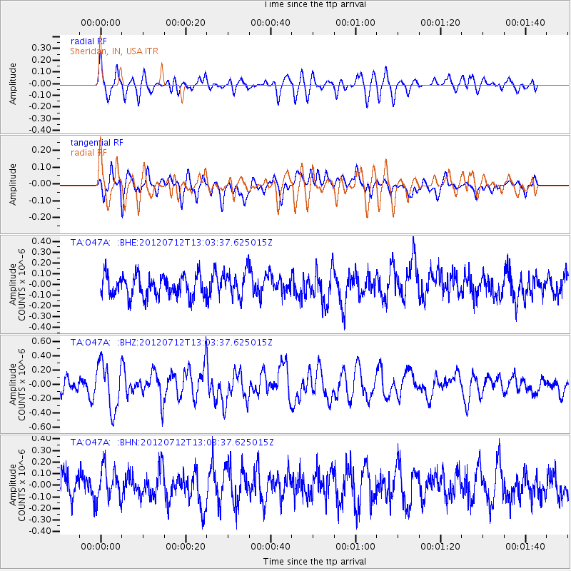
O47A Sheridan, IN, USA - Earthquake Result Viewer
*The percent match for this event was below the threshold and hence no stack was calculated.
| Earthquake location: |
Kuril Islands |
| Earthquake latitude/longitude: |
45.5/151.7 |
| Earthquake time(UTC): |
2012/07/12 (194) 12:51:58 GMT |
| Earthquake Depth: |
12 km |
| Earthquake Magnitude: |
5.5 MB, 5.6 MS, 5.8 MW, 5.7 MW |
| Earthquake Catalog/Contributor: |
WHDF/NEIC |
|
| Network: |
TA USArray Transportable Network (new EarthScope stations) |
| Station: |
O47A Sheridan, IN, USA |
| Lat/Lon: |
40.24 N/86.17 W |
| Elevation: |
278 m |
|
| Distance: |
80.2 deg |
| Az: |
41.121 deg |
| Baz: |
322.792 deg |
| Ray Param: |
$rayparam |
*The percent match for this event was below the threshold and hence was not used in the summary stack. |
|
| Radial Match: |
64.0121 % |
| Radial Bump: |
400 |
| Transverse Match: |
56.70265 % |
| Transverse Bump: |
400 |
| SOD ConfigId: |
467763 |
| Insert Time: |
2013-02-21 17:30:22.804 +0000 |
| GWidth: |
2.5 |
| Max Bumps: |
400 |
| Tol: |
0.001 |
|
Signal To Noise
| Channel | StoN | STA | LTA |
| TA:O47A: :BHZ:20120712T13:03:37.625015Z | 3.1978104 | 3.3689645E-7 | 1.0535223E-7 |
| TA:O47A: :BHN:20120712T13:03:37.625015Z | 1.1682894 | 1.3838883E-7 | 1.1845423E-7 |
| TA:O47A: :BHE:20120712T13:03:37.625015Z | 1.3090348 | 1.2728654E-7 | 9.723694E-8 |
| Arrivals |
| Ps | |
| PpPs | |
| PsPs/PpSs | |


