You are here: Home > Network List > TA - USArray Transportable Network (new EarthScope stations) Stations List
> Station 154A Montrose, GA, USA > Earthquake Result Viewer
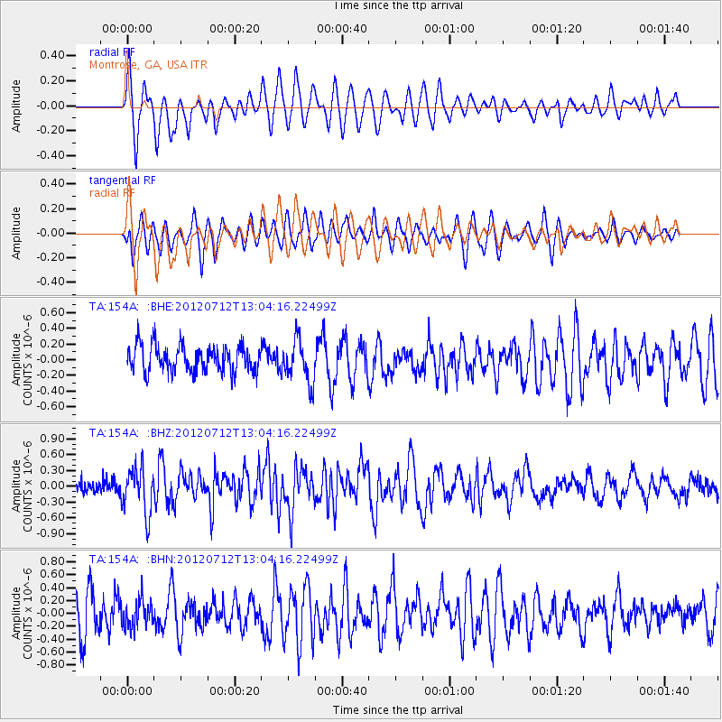
154A Montrose, GA, USA - Earthquake Result Viewer
*The percent match for this event was below the threshold and hence no stack was calculated.
| Earthquake location: |
Kuril Islands |
| Earthquake latitude/longitude: |
45.5/151.7 |
| Earthquake time(UTC): |
2012/07/12 (194) 12:51:58 GMT |
| Earthquake Depth: |
12 km |
| Earthquake Magnitude: |
5.5 MB, 5.6 MS, 5.8 MW, 5.7 MW |
| Earthquake Catalog/Contributor: |
WHDF/NEIC |
|
| Network: |
TA USArray Transportable Network (new EarthScope stations) |
| Station: |
154A Montrose, GA, USA |
| Lat/Lon: |
32.61 N/83.11 W |
| Elevation: |
111 m |
|
| Distance: |
87.8 deg |
| Az: |
43.623 deg |
| Baz: |
324.872 deg |
| Ray Param: |
$rayparam |
*The percent match for this event was below the threshold and hence was not used in the summary stack. |
|
| Radial Match: |
67.77793 % |
| Radial Bump: |
400 |
| Transverse Match: |
67.45013 % |
| Transverse Bump: |
400 |
| SOD ConfigId: |
467763 |
| Insert Time: |
2013-02-21 17:34:10.630 +0000 |
| GWidth: |
2.5 |
| Max Bumps: |
400 |
| Tol: |
0.001 |
|
Signal To Noise
| Channel | StoN | STA | LTA |
| TA:154A: :BHZ:20120712T13:04:16.22499Z | 3.8061042 | 4.4097206E-7 | 1.15859166E-7 |
| TA:154A: :BHN:20120712T13:04:16.22499Z | 0.75633734 | 2.0562025E-7 | 2.7186314E-7 |
| TA:154A: :BHE:20120712T13:04:16.22499Z | 1.6667639 | 2.775259E-7 | 1.6650583E-7 |
| Arrivals |
| Ps | |
| PpPs | |
| PsPs/PpSs | |


