You are here: Home > Network List > TA - USArray Transportable Network (new EarthScope stations) Stations List
> Station Q48A North Vernon, IN, USA > Earthquake Result Viewer
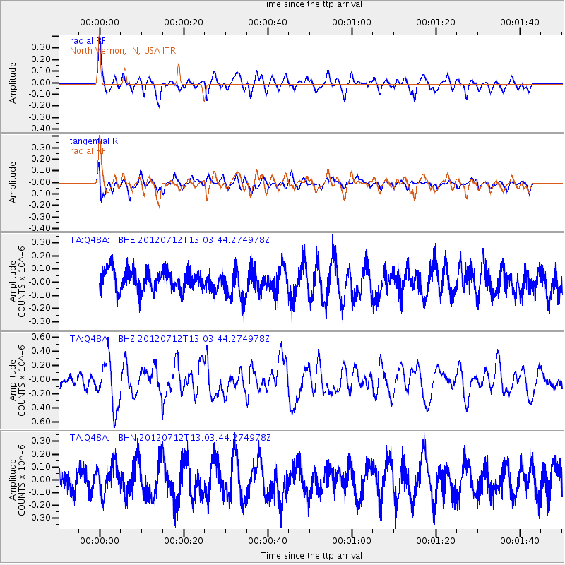
Q48A North Vernon, IN, USA - Earthquake Result Viewer
*The percent match for this event was below the threshold and hence no stack was calculated.
| Earthquake location: |
Kuril Islands |
| Earthquake latitude/longitude: |
45.5/151.7 |
| Earthquake time(UTC): |
2012/07/12 (194) 12:51:58 GMT |
| Earthquake Depth: |
12 km |
| Earthquake Magnitude: |
5.5 MB, 5.6 MS, 5.8 MW, 5.7 MW |
| Earthquake Catalog/Contributor: |
WHDF/NEIC |
|
| Network: |
TA USArray Transportable Network (new EarthScope stations) |
| Station: |
Q48A North Vernon, IN, USA |
| Lat/Lon: |
38.93 N/85.73 W |
| Elevation: |
185 m |
|
| Distance: |
81.4 deg |
| Az: |
41.64 deg |
| Baz: |
323.156 deg |
| Ray Param: |
$rayparam |
*The percent match for this event was below the threshold and hence was not used in the summary stack. |
|
| Radial Match: |
73.83802 % |
| Radial Bump: |
400 |
| Transverse Match: |
55.83716 % |
| Transverse Bump: |
400 |
| SOD ConfigId: |
467763 |
| Insert Time: |
2013-02-21 17:37:32.840 +0000 |
| GWidth: |
2.5 |
| Max Bumps: |
400 |
| Tol: |
0.001 |
|
Signal To Noise
| Channel | StoN | STA | LTA |
| TA:Q48A: :BHZ:20120712T13:03:44.274978Z | 2.746009 | 3.3845535E-7 | 1.2325353E-7 |
| TA:Q48A: :BHN:20120712T13:03:44.274978Z | 1.0012357 | 1.1113035E-7 | 1.109932E-7 |
| TA:Q48A: :BHE:20120712T13:03:44.274978Z | 1.58969 | 1.2013241E-7 | 7.5569716E-8 |
| Arrivals |
| Ps | |
| PpPs | |
| PsPs/PpSs | |


