You are here: Home > Network List > TA - USArray Transportable Network (new EarthScope stations) Stations List
> Station A33A Warroad, MN, USA > Earthquake Result Viewer
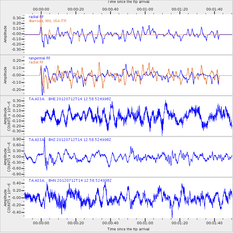
A33A Warroad, MN, USA - Earthquake Result Viewer
*The percent match for this event was below the threshold and hence no stack was calculated.
| Earthquake location: |
Hindu Kush Region, Afghanistan |
| Earthquake latitude/longitude: |
36.5/70.9 |
| Earthquake time(UTC): |
2012/07/12 (194) 14:00:34 GMT |
| Earthquake Depth: |
198 km |
| Earthquake Magnitude: |
5.6 MB, 5.7 MW, 5.8 MW |
| Earthquake Catalog/Contributor: |
WHDF/NEIC |
|
| Network: |
TA USArray Transportable Network (new EarthScope stations) |
| Station: |
A33A Warroad, MN, USA |
| Lat/Lon: |
48.94 N/95.39 W |
| Elevation: |
329 m |
|
| Distance: |
94.0 deg |
| Az: |
350.99 deg |
| Baz: |
11.028 deg |
| Ray Param: |
$rayparam |
*The percent match for this event was below the threshold and hence was not used in the summary stack. |
|
| Radial Match: |
67.29971 % |
| Radial Bump: |
400 |
| Transverse Match: |
76.391365 % |
| Transverse Bump: |
400 |
| SOD ConfigId: |
467763 |
| Insert Time: |
2013-02-21 17:51:06.063 +0000 |
| GWidth: |
2.5 |
| Max Bumps: |
400 |
| Tol: |
0.001 |
|
Signal To Noise
| Channel | StoN | STA | LTA |
| TA:A33A: :BHZ:20120712T14:12:58.524998Z | 2.0774324 | 3.463553E-7 | 1.6672278E-7 |
| TA:A33A: :BHN:20120712T14:12:58.524998Z | 1.5097417 | 1.6438626E-7 | 1.08883704E-7 |
| TA:A33A: :BHE:20120712T14:12:58.524998Z | 0.9569566 | 7.836847E-8 | 8.189344E-8 |
| Arrivals |
| Ps | |
| PpPs | |
| PsPs/PpSs | |


