You are here: Home > Network List > CI - Caltech Regional Seismic Network Stations List
> Station SMM Simmler, CA, USA > Earthquake Result Viewer
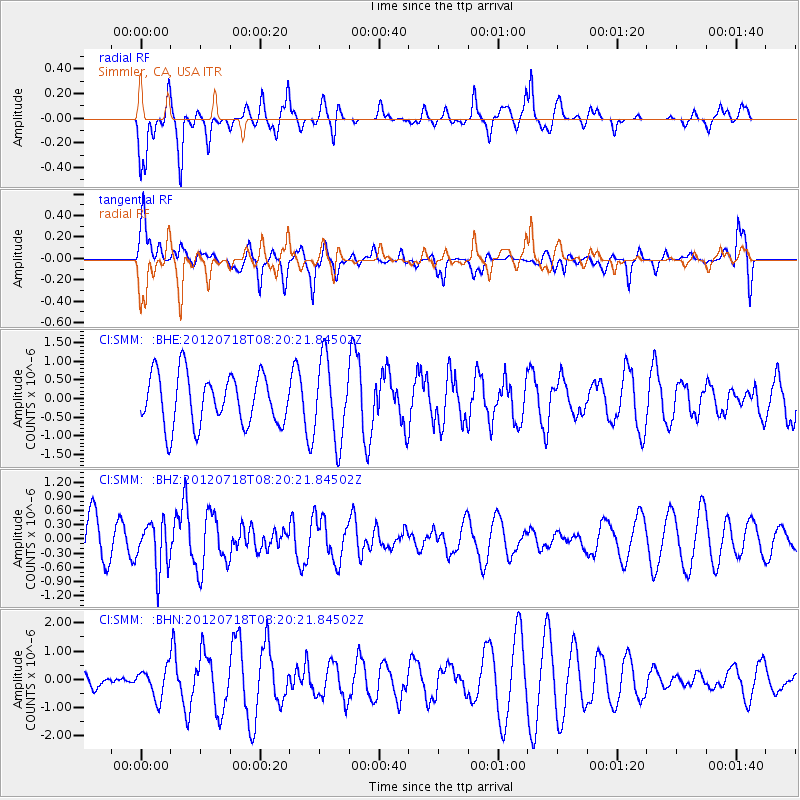
SMM Simmler, CA, USA - Earthquake Result Viewer
*The percent match for this event was below the threshold and hence no stack was calculated.
| Earthquake location: |
Fiji Islands Region |
| Earthquake latitude/longitude: |
-20.9/-178.5 |
| Earthquake time(UTC): |
2012/07/18 (200) 08:09:46 GMT |
| Earthquake Depth: |
537 km |
| Earthquake Magnitude: |
5.5 MB, 5.9 MW, 6.0 MW |
| Earthquake Catalog/Contributor: |
WHDF/NEIC |
|
| Network: |
CI Caltech Regional Seismic Network |
| Station: |
SMM Simmler, CA, USA |
| Lat/Lon: |
35.31 N/120.00 W |
| Elevation: |
599 m |
|
| Distance: |
78.7 deg |
| Az: |
45.328 deg |
| Baz: |
234.408 deg |
| Ray Param: |
$rayparam |
*The percent match for this event was below the threshold and hence was not used in the summary stack. |
|
| Radial Match: |
51.53732 % |
| Radial Bump: |
343 |
| Transverse Match: |
38.812016 % |
| Transverse Bump: |
368 |
| SOD ConfigId: |
467763 |
| Insert Time: |
2013-02-21 18:20:59.237 +0000 |
| GWidth: |
2.5 |
| Max Bumps: |
400 |
| Tol: |
0.001 |
|
Signal To Noise
| Channel | StoN | STA | LTA |
| CI:SMM: :BHZ:20120718T08:20:21.84502Z | 0.7661229 | 5.070359E-7 | 6.618206E-7 |
| CI:SMM: :BHN:20120718T08:20:21.84502Z | 0.9990642 | 5.2252506E-7 | 5.230145E-7 |
| CI:SMM: :BHE:20120718T08:20:21.84502Z | 1.5702356 | 1.0665707E-6 | 6.792425E-7 |
| Arrivals |
| Ps | |
| PpPs | |
| PsPs/PpSs | |


