You are here: Home > Network List > CN - Canadian National Seismograph Network Stations List
> Station INK INUVIK, NT > Earthquake Result Viewer
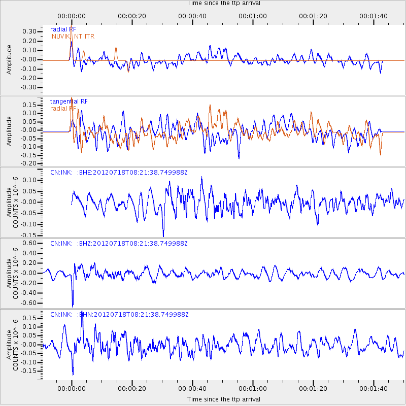
INK INUVIK, NT - Earthquake Result Viewer
*The percent match for this event was below the threshold and hence no stack was calculated.
| Earthquake location: |
Fiji Islands Region |
| Earthquake latitude/longitude: |
-20.9/-178.5 |
| Earthquake time(UTC): |
2012/07/18 (200) 08:09:46 GMT |
| Earthquake Depth: |
537 km |
| Earthquake Magnitude: |
5.5 MB, 5.9 MW, 6.0 MW |
| Earthquake Catalog/Contributor: |
WHDF/NEIC |
|
| Network: |
CN Canadian National Seismograph Network |
| Station: |
INK INUVIK, NT |
| Lat/Lon: |
68.31 N/133.53 W |
| Elevation: |
44 m |
|
| Distance: |
94.8 deg |
| Az: |
15.291 deg |
| Baz: |
221.556 deg |
| Ray Param: |
$rayparam |
*The percent match for this event was below the threshold and hence was not used in the summary stack. |
|
| Radial Match: |
40.666927 % |
| Radial Bump: |
400 |
| Transverse Match: |
48.31435 % |
| Transverse Bump: |
400 |
| SOD ConfigId: |
467763 |
| Insert Time: |
2013-02-21 18:23:00.472 +0000 |
| GWidth: |
2.5 |
| Max Bumps: |
400 |
| Tol: |
0.001 |
|
Signal To Noise
| Channel | StoN | STA | LTA |
| CN:INK: :BHZ:20120718T08:21:38.749988Z | 4.3809466 | 2.0139973E-7 | 4.597174E-8 |
| CN:INK: :BHN:20120718T08:21:38.749988Z | 3.5627248 | 7.6892064E-8 | 2.1582375E-8 |
| CN:INK: :BHE:20120718T08:21:38.749988Z | 1.8653077 | 5.9688304E-8 | 3.199917E-8 |
| Arrivals |
| Ps | |
| PpPs | |
| PsPs/PpSs | |


