You are here: Home > Network List > G - GEOSCOPE Stations List
> Station INU Inuyama, Japan > Earthquake Result Viewer
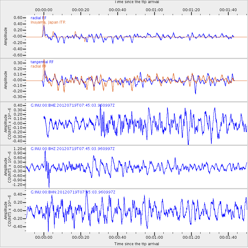
INU Inuyama, Japan - Earthquake Result Viewer
*The percent match for this event was below the threshold and hence no stack was calculated.
| Earthquake location: |
Afghanistan-Tajikistan Bord Reg. |
| Earthquake latitude/longitude: |
37.2/71.4 |
| Earthquake time(UTC): |
2012/07/19 (201) 07:36:35 GMT |
| Earthquake Depth: |
98 km |
| Earthquake Magnitude: |
5.5 MB, 5.6 MW, 5.6 MW |
| Earthquake Catalog/Contributor: |
WHDF/NEIC |
|
| Network: |
G GEOSCOPE |
| Station: |
INU Inuyama, Japan |
| Lat/Lon: |
35.35 N/137.03 E |
| Elevation: |
132 m |
|
| Distance: |
52.0 deg |
| Az: |
70.995 deg |
| Baz: |
292.638 deg |
| Ray Param: |
$rayparam |
*The percent match for this event was below the threshold and hence was not used in the summary stack. |
|
| Radial Match: |
67.12435 % |
| Radial Bump: |
400 |
| Transverse Match: |
54.187603 % |
| Transverse Bump: |
400 |
| SOD ConfigId: |
468427 |
| Insert Time: |
2013-02-21 21:56:52.887 +0000 |
| GWidth: |
2.5 |
| Max Bumps: |
400 |
| Tol: |
0.001 |
|
Signal To Noise
| Channel | StoN | STA | LTA |
| G:INU:00:BHZ:20120719T07:45:03.960997Z | 4.210481 | 4.7334453E-7 | 1.1242054E-7 |
| G:INU:00:BHN:20120719T07:45:03.960997Z | 1.5394028 | 1.8518207E-7 | 1.2029474E-7 |
| G:INU:00:BHE:20120719T07:45:03.960997Z | 1.9100752 | 1.7744381E-7 | 9.2898865E-8 |
| Arrivals |
| Ps | |
| PpPs | |
| PsPs/PpSs | |


