You are here: Home > Network List > UW - Pacific Northwest Regional Seismic Network Stations List
> Station MRBL Marblemount, WA, USA > Earthquake Result Viewer
MRBL Marblemount, WA, USA - Earthquake Result Viewer
*The percent match for this event was below the threshold and hence no stack was calculated.
| Earthquake location: |
Afghanistan-Tajikistan Bord Reg. |
| Earthquake latitude/longitude: |
37.2/71.4 |
| Earthquake time(UTC): |
2012/07/19 (201) 07:36:35 GMT |
| Earthquake Depth: |
98 km |
| Earthquake Magnitude: |
5.5 MB, 5.6 MW, 5.6 MW |
| Earthquake Catalog/Contributor: |
WHDF/NEIC |
|
| Network: |
UW Pacific Northwest Regional Seismic Network |
| Station: |
MRBL Marblemount, WA, USA |
| Lat/Lon: |
48.52 N/121.48 W |
| Elevation: |
75 m |
|
| Distance: |
93.8 deg |
| Az: |
8.529 deg |
| Baz: |
349.747 deg |
| Ray Param: |
$rayparam |
*The percent match for this event was below the threshold and hence was not used in the summary stack. |
|
| Radial Match: |
51.365498 % |
| Radial Bump: |
400 |
| Transverse Match: |
67.59748 % |
| Transverse Bump: |
400 |
| SOD ConfigId: |
468427 |
| Insert Time: |
2013-02-21 22:07:39.758 +0000 |
| GWidth: |
2.5 |
| Max Bumps: |
400 |
| Tol: |
0.001 |
|
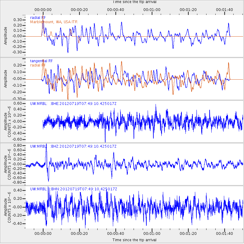
Signal To Noise
| Channel | StoN | STA | LTA |
| UW:MRBL: :BHZ:20120719T07:49:10.425017Z | 5.206164 | 3.2855468E-7 | 6.3108786E-8 |
| UW:MRBL: :BHN:20120719T07:49:10.425017Z | 1.5366211 | 1.959242E-7 | 1.2750326E-7 |
| UW:MRBL: :BHE:20120719T07:49:10.425017Z | 1.5040708 | 1.5751166E-7 | 1.0472357E-7 |
| Arrivals |
| Ps | |
| PpPs | |
| PsPs/PpSs | |


