You are here: Home > Network List > CI - Caltech Regional Seismic Network Stations List
> Station SLA SLA, Trona, CA, USA > Earthquake Result Viewer
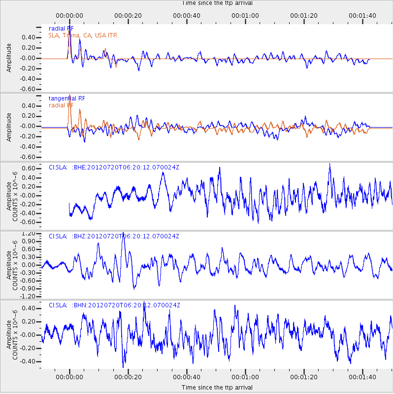
SLA SLA, Trona, CA, USA - Earthquake Result Viewer
*The percent match for this event was below the threshold and hence no stack was calculated.
| Earthquake location: |
Kuril Islands |
| Earthquake latitude/longitude: |
49.4/155.9 |
| Earthquake time(UTC): |
2012/07/20 (202) 06:10:25 GMT |
| Earthquake Depth: |
19 km |
| Earthquake Magnitude: |
5.7 MB, 5.7 MS, 6.0 MW, 6.1 MW |
| Earthquake Catalog/Contributor: |
WHDF/NEIC |
|
| Network: |
CI Caltech Regional Seismic Network |
| Station: |
SLA SLA, Trona, CA, USA |
| Lat/Lon: |
35.89 N/117.28 W |
| Elevation: |
1174 m |
|
| Distance: |
61.9 deg |
| Az: |
66.827 deg |
| Baz: |
312.308 deg |
| Ray Param: |
$rayparam |
*The percent match for this event was below the threshold and hence was not used in the summary stack. |
|
| Radial Match: |
68.023796 % |
| Radial Bump: |
400 |
| Transverse Match: |
43.68074 % |
| Transverse Bump: |
400 |
| SOD ConfigId: |
468427 |
| Insert Time: |
2013-02-21 22:12:41.869 +0000 |
| GWidth: |
2.5 |
| Max Bumps: |
400 |
| Tol: |
0.001 |
|
Signal To Noise
| Channel | StoN | STA | LTA |
| CI:SLA: :BHZ:20120720T06:20:12.070024Z | 2.975209 | 2.5276225E-7 | 8.4956135E-8 |
| CI:SLA: :BHN:20120720T06:20:12.070024Z | 1.4464295 | 1.8398005E-7 | 1.27196E-7 |
| CI:SLA: :BHE:20120720T06:20:12.070024Z | 1.7375612 | 3.3174544E-7 | 1.909259E-7 |
| Arrivals |
| Ps | |
| PpPs | |
| PsPs/PpSs | |


