You are here: Home > Network List > DK - Danish Seismological Network Stations List
> Station DBG Daneborg, Greenland > Earthquake Result Viewer
DBG Daneborg, Greenland - Earthquake Result Viewer

| Earthquake location: |
Kuril Islands |
| Earthquake latitude/longitude: |
49.4/155.9 |
| Earthquake time(UTC): |
2012/07/20 (202) 06:10:25 GMT |
| Earthquake Depth: |
19 km |
| Earthquake Magnitude: |
5.7 MB, 5.7 MS, 6.0 MW, 6.1 MW |
| Earthquake Catalog/Contributor: |
WHDF/NEIC |
|
| Network: |
DK Danish Seismological Network |
| Station: |
DBG Daneborg, Greenland |
| Lat/Lon: |
74.31 N/20.22 W |
| Elevation: |
1.0 m |
|
| Distance: |
56.5 deg |
| Az: |
358.737 deg |
| Baz: |
3.032 deg |
| Ray Param: |
0.06404857 |
| Estimated Moho Depth: |
22.25 km |
| Estimated Crust Vp/Vs: |
1.77 |
| Assumed Crust Vp: |
6.459 km/s |
| Estimated Crust Vs: |
3.644 km/s |
| Estimated Crust Poisson's Ratio: |
0.27 |
|
| Radial Match: |
86.59501 % |
| Radial Bump: |
400 |
| Transverse Match: |
68.89945 % |
| Transverse Bump: |
400 |
| SOD ConfigId: |
468427 |
| Insert Time: |
2013-02-21 22:13:54.808 +0000 |
| GWidth: |
2.5 |
| Max Bumps: |
400 |
| Tol: |
0.001 |
|
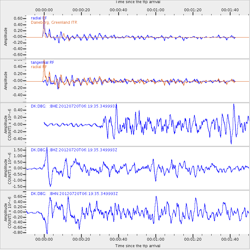
Signal To Noise
| Channel | StoN | STA | LTA |
| DK:DBG: :BHZ:20120720T06:19:35.349993Z | 20.953808 | 8.9723295E-7 | 4.281956E-8 |
| DK:DBG: :BHN:20120720T06:19:35.349993Z | 12.916505 | 4.1297187E-7 | 3.1972416E-8 |
| DK:DBG: :BHE:20120720T06:19:35.349993Z | 5.9965005 | 1.3921068E-7 | 2.3215321E-8 |
| Arrivals |
| Ps | 2.8 SECOND |
| PpPs | 9.1 SECOND |
| PsPs/PpSs | 12 SECOND |


