You are here: Home > Network List > G - GEOSCOPE Stations List
> Station IVI Ivittuut, Greenland > Earthquake Result Viewer
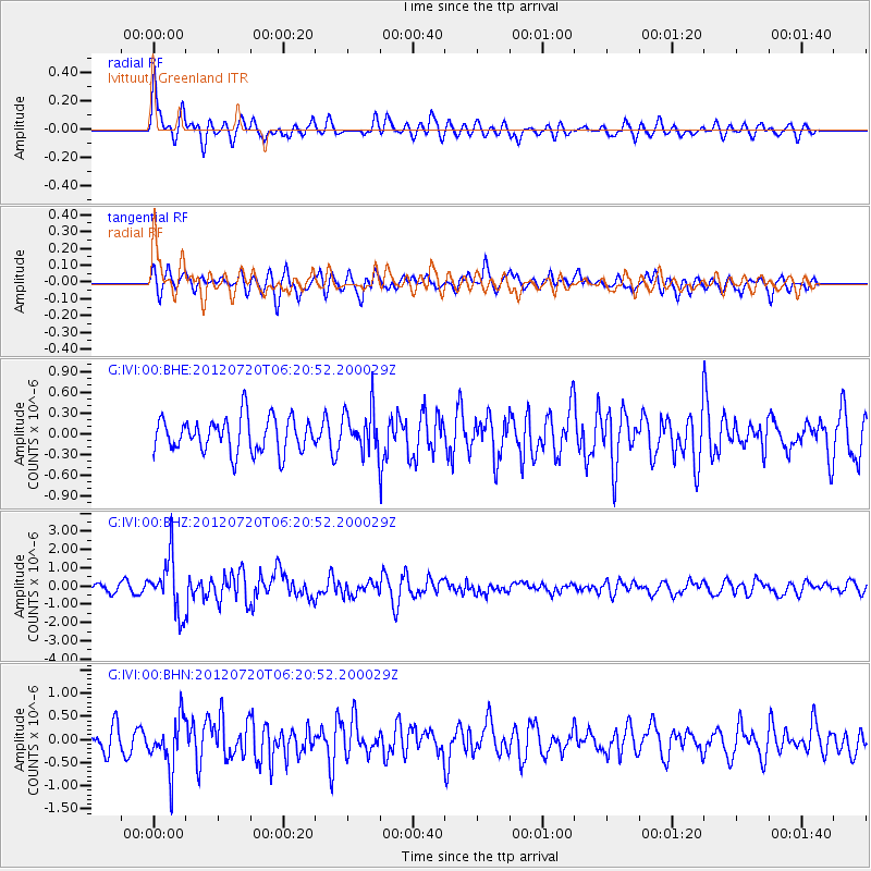
IVI Ivittuut, Greenland - Earthquake Result Viewer
*The percent match for this event was below the threshold and hence no stack was calculated.
| Earthquake location: |
Kuril Islands |
| Earthquake latitude/longitude: |
49.4/155.9 |
| Earthquake time(UTC): |
2012/07/20 (202) 06:10:25 GMT |
| Earthquake Depth: |
19 km |
| Earthquake Magnitude: |
5.7 MB, 5.7 MS, 6.0 MW, 6.1 MW |
| Earthquake Catalog/Contributor: |
WHDF/NEIC |
|
| Network: |
G GEOSCOPE |
| Station: |
IVI Ivittuut, Greenland |
| Lat/Lon: |
61.21 N/48.17 W |
| Elevation: |
15 m |
|
| Distance: |
68.1 deg |
| Az: |
12.296 deg |
| Baz: |
343.302 deg |
| Ray Param: |
$rayparam |
*The percent match for this event was below the threshold and hence was not used in the summary stack. |
|
| Radial Match: |
75.875244 % |
| Radial Bump: |
400 |
| Transverse Match: |
56.876625 % |
| Transverse Bump: |
400 |
| SOD ConfigId: |
468427 |
| Insert Time: |
2013-02-21 22:14:09.583 +0000 |
| GWidth: |
2.5 |
| Max Bumps: |
400 |
| Tol: |
0.001 |
|
Signal To Noise
| Channel | StoN | STA | LTA |
| G:IVI:00:BHZ:20120720T06:20:52.200029Z | 6.238765 | 1.4931007E-6 | 2.3932634E-7 |
| G:IVI:00:BHN:20120720T06:20:52.200029Z | 2.1263669 | 5.4492745E-7 | 2.5627162E-7 |
| G:IVI:00:BHE:20120720T06:20:52.200029Z | 1.2269298 | 3.0549438E-7 | 2.4899094E-7 |
| Arrivals |
| Ps | |
| PpPs | |
| PsPs/PpSs | |


