You are here: Home > Network List > G - GEOSCOPE Stations List
> Station SSB Saint Sauveur Badole, France > Earthquake Result Viewer
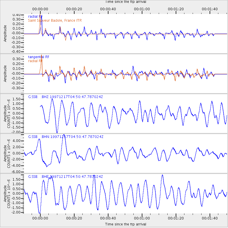
SSB Saint Sauveur Badole, France - Earthquake Result Viewer
*The percent match for this event was below the threshold and hence no stack was calculated.
| Earthquake location: |
Rat Islands, Aleutian Islands |
| Earthquake latitude/longitude: |
51.2/178.9 |
| Earthquake time(UTC): |
1997/12/17 (351) 04:38:51 GMT |
| Earthquake Depth: |
20 km |
| Earthquake Magnitude: |
5.8 MB, 6.5 MS, 6.7 UNKNOWN, 6.1 ME |
| Earthquake Catalog/Contributor: |
WHDF/NEIC |
|
| Network: |
G GEOSCOPE |
| Station: |
SSB Saint Sauveur Badole, France |
| Lat/Lon: |
45.28 N/4.54 E |
| Elevation: |
700 m |
|
| Distance: |
83.8 deg |
| Az: |
355.976 deg |
| Baz: |
3.587 deg |
| Ray Param: |
$rayparam |
*The percent match for this event was below the threshold and hence was not used in the summary stack. |
|
| Radial Match: |
75.21221 % |
| Radial Bump: |
369 |
| Transverse Match: |
44.504696 % |
| Transverse Bump: |
400 |
| SOD ConfigId: |
4480 |
| Insert Time: |
2010-02-27 00:21:09.402 +0000 |
| GWidth: |
2.5 |
| Max Bumps: |
400 |
| Tol: |
0.001 |
|
Signal To Noise
| Channel | StoN | STA | LTA |
| G:SSB: :BHN:19971217T04:50:47.787024Z | 4.665241 | 3.3289602E-6 | 7.1356664E-7 |
| G:SSB: :BHE:19971217T04:50:47.787024Z | 1.6739966 | 1.2369338E-6 | 7.389106E-7 |
| G:SSB: :BHZ:19971217T04:50:47.787024Z | 0.7233029 | 6.585722E-7 | 9.105068E-7 |
| Arrivals |
| Ps | |
| PpPs | |
| PsPs/PpSs | |


