You are here: Home > Network List > MN - MEDNET Project Stations List
> Station WDD Wield Dalam, Malta > Earthquake Result Viewer
WDD Wield Dalam, Malta - Earthquake Result Viewer
| Earthquake location: |
Kuril Islands |
| Earthquake latitude/longitude: |
49.4/155.9 |
| Earthquake time(UTC): |
2012/07/20 (202) 06:10:25 GMT |
| Earthquake Depth: |
19 km |
| Earthquake Magnitude: |
5.7 MB, 5.7 MS, 6.0 MW, 6.1 MW |
| Earthquake Catalog/Contributor: |
WHDF/NEIC |
|
| Network: |
MN MEDNET Project |
| Station: |
WDD Wield Dalam, Malta |
| Lat/Lon: |
35.87 N/14.52 E |
| Elevation: |
41 m |
|
| Distance: |
88.4 deg |
| Az: |
329.529 deg |
| Baz: |
24.067 deg |
| Ray Param: |
0.04256593 |
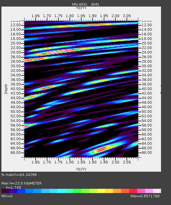
| Estimated Moho Depth: |
23.5 km |
| Estimated Crust Vp/Vs: |
1.75 |
| Assumed Crust Vp: |
4.05 km/s |
| Estimated Crust Vs: |
2.321 km/s |
| Estimated Crust Poisson's Ratio: |
0.26 |
|
| Radial Match: |
84.34299 % |
| Radial Bump: |
400 |
| Transverse Match: |
81.105255 % |
| Transverse Bump: |
400 |
| SOD ConfigId: |
468427 |
| Insert Time: |
2013-02-21 22:22:12.529 +0000 |
| GWidth: |
2.5 |
| Max Bumps: |
400 |
| Tol: |
0.001 |
|

Signal To Noise
| Channel | StoN | STA | LTA |
| MN:WDD: :BHZ:20120720T06:22:44.682024Z | 9.38955 | 1.9447536E-6 | 2.0711894E-7 |
| MN:WDD: :BHN:20120720T06:22:44.682024Z | 2.5637026 | 4.573814E-7 | 1.7840658E-7 |
| MN:WDD: :BHE:20120720T06:22:44.682024Z | 1.4963841 | 2.7388725E-7 | 1.8303271E-7 |
| Arrivals |
| Ps | 4.4 SECOND |
| PpPs | 16 SECOND |
| PsPs/PpSs | 20 SECOND |


